Fisherman's WharfQuirin Hohendorf
Summary
I researched the industrial history of Fisherman’s Wharf and the dramatic changes in the shoreline in the last 130 years. The area has undergone the transition from a sparsely settled area to an industrial area in the first half of the 20th century, to a tourist destination in the present. The park upland from Fisherman’s Wharf was recently re-designed with a raingarden as its main feature. The area will probably keep its recreational character into the middle future (at least twenty years). Significant loss of land area and a change in species composition will likely occur due to climate change and sea level rise in coming decades. |
|
Genealogy
|
My project area in the James Bay neighbourhood expands westwards from St. Lawrence Street and is enclosed by the water in the north and Erie Street and Huron Street in the south (blue, Figure 1).
When James Douglas sailed to the south end of Vancouver Island to found a new fort, he came to an area that was called “Camosak” or “Camosun”, the Songhees’ territory around todays Downtown Victoria. He anchored in the area that is now called Fisherman´s Wharf (Camas Historical Group, 1978). The Songhees most likely used the flat intertidal zone of Fisherman´s Wharf for the collection of shellfish. The area around todays Victoria was a Garry oak-grassland and was used as harvesting ground for Great Camas (Camassia leichtlinii) (Foster, 1967). The comparison of a map from 1884 and today shows a significant change in the shoreline (Figure 2). There is legitimate doubt in the preciseness of the 1884 map, but a change is obvious. The beach was altered along the whole length of the shoreline.
After Fort Victoria was established, the area around Fisherman´s Wharf was used as farmland for a long time (Camas Historical Group, 1978) and had remains of forest at least into the 1870s (Figure 3). 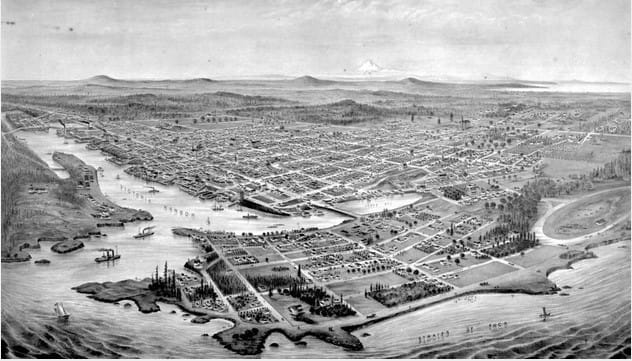
Figure 3: Bird eyes view of Victoria, 1878. BC Archives, PDP 00223
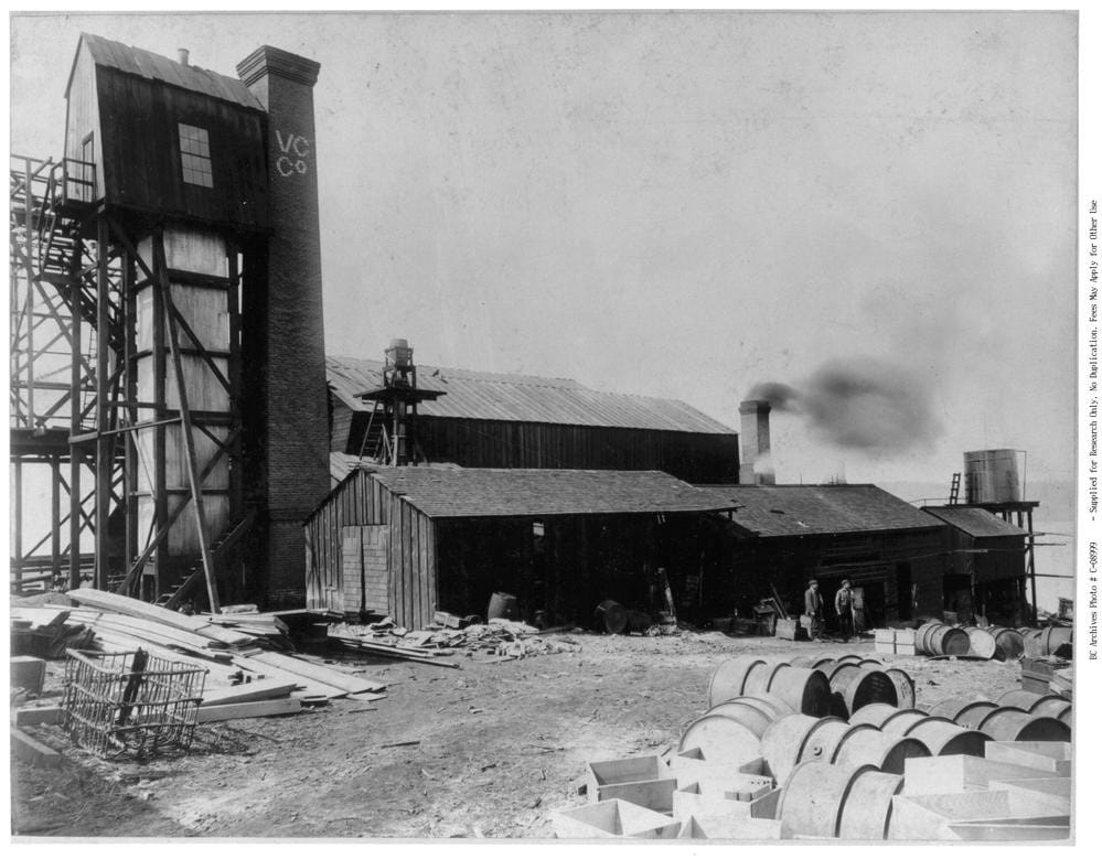
Figure 4: Victoria Chemical Co, 1890s. 1890s. BC Archives, C-08999
|
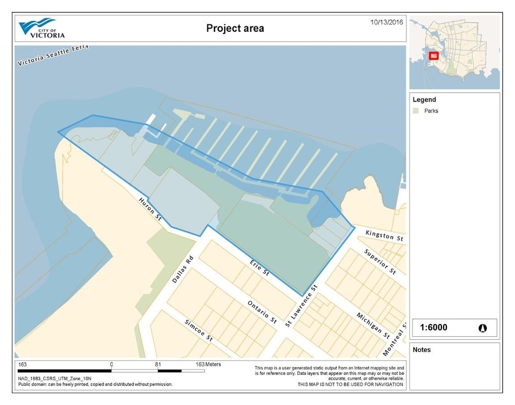
Figure 1: Project area
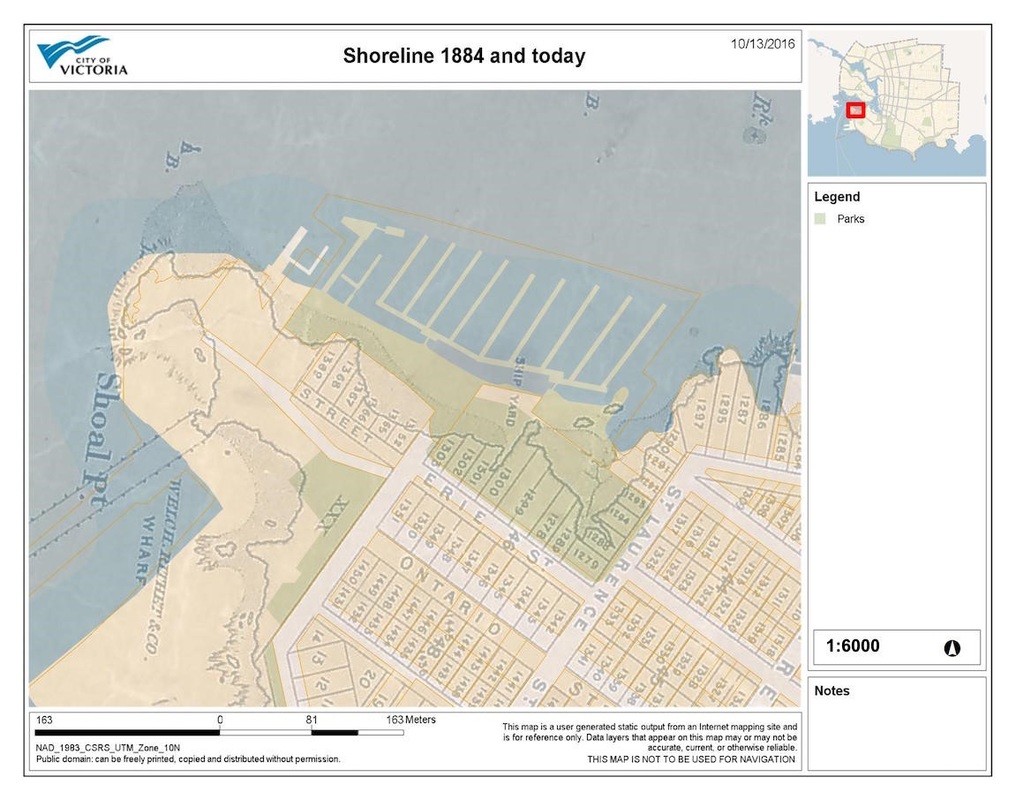
Figure 2: Shoreline 1884 and today
The area was used by small industries. On the fire insurance plan of 1895, the Brackman & Ker Milling Co. Ltd. (Figure 5) is recorded on the west end of Erie Street. It had only a flour mill and a grain house. The company used a “wooden wharf built on piles” (Goad, 1895) to ship goods. Right next to Brackman & Ker there was the Victoria Chemical Co. Ltd (Figure 4). Several storage cylinders and small buildings spread out over the property. The company had a small wooden dock. The rest of the shoreline of the area was relatively untouched (see Figure 3) (Goad, 1895). There were a few houses on the north side of Erie Street, but no dock yet. Erie Street was connected to downtown with an electrical train which seems to have been removed before the next edition of the fire insurance plan in 1903 (Goad, 1903). In 1903 the industry had significantly expanded (Figure 6). Brackman & Ker had several industrial buildings and storage houses, and their wharf tripled in size (Goad, 1903). Victoria Chemical Co grew as well. They had expanded their wharf and several new buildings (including a "Nitric Acid |
House” and a “Sulfuric Acid Chamber”) (Goad, 1903). On the corner of Erie Street and St. Lawrence Street a new business (R. Ward & Co.) first appears on a map, with access to a small dock where Fisherman´s wharf is located today.
In 1913, the first house boats had appeared around the little bay east of Fisherman´s Wharf. Both “big businesses” Brackman & Ker and Victoria Chemical Co. continued to grow, even though the growth was not as significant as it was before. Victoria Chemical Co. expanded their wharf over the whole length of the property’s waterfront.
In 1913, the first house boats had appeared around the little bay east of Fisherman´s Wharf. Both “big businesses” Brackman & Ker and Victoria Chemical Co. continued to grow, even though the growth was not as significant as it was before. Victoria Chemical Co. expanded their wharf over the whole length of the property’s waterfront.
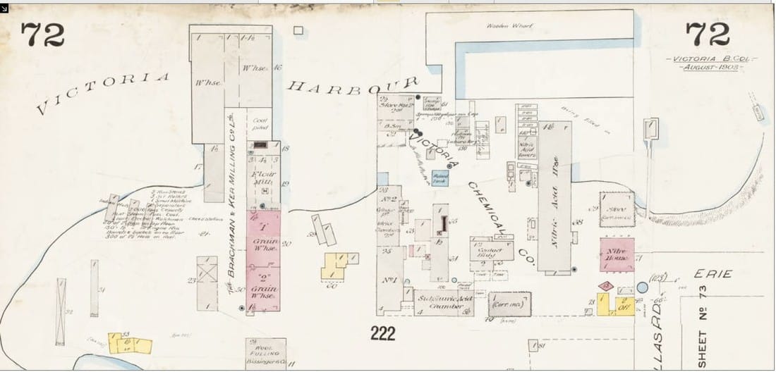
Figure 6: Fire insurance plan, 1903 (Goad, 1903)
|
It is likely that the industry had effects on terrestrial, intertidal and marine life in the area. It is possible that chemicals spilled into the soil or water. The 1903 map shows a (uncovered) coal pile on the wharf of the milling company. The area gained new importance with the opening of Fisherman´s Wharf in 1946. It consisted of one main float and six branch floats, hosting about 200 boats (Camas Historical Group, 1978). The bay was filled in between 1957 and 1968 and Odgen Point at the west end of the study area was still partly undeveloped in 1968 (Figure 7). |
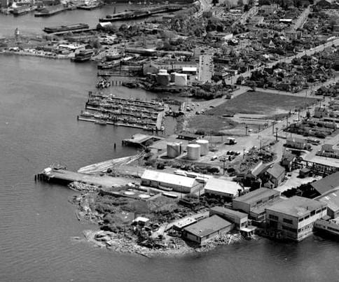
Figure 7: Aerial photograph of James Bay and Fisherman´s Wharf, 1968. BC Archives, I-26479 (modified)
|
Socio-ecological characterization
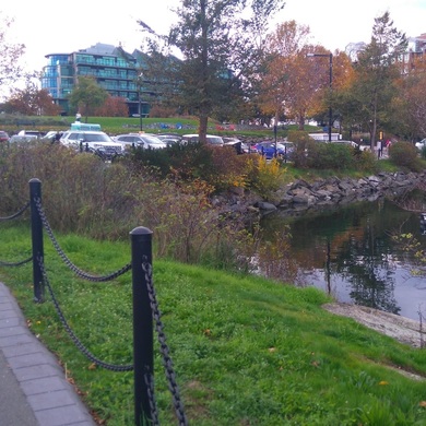
Today, Fisherman’s Wharf and its surroundings are mainly used for recreation. There are several businesses on the wharf, catering food to tourists and locals. 33 float homes in different styles add to the colourful impression of the area, and the wharf can host up to 101 boats on berths (Greater Victoria Harbour Authority, 2013). There are still fishing boats, and the Fisherman’s Wharf Plan suggests to create more visibility for the industry, that is, enabling tourists to watch fishing boats load and unload on the dock (Greater Victoria Harbour Authority, 2013). On land, there is a parking lot with 153 stalls in total, creating an ecological barrier between the shore and the park that did not exist before (Figure 8). Fisherman’s Wharf is now owned by the Greater Victoria Harbour Authority (GVHA) after it was bought from the federal government in 2002 (Greater Victoria Harbour Authority, 2013).
Regulations and policies by the City of Victoria concerning Fisherman’s Wharf can be found in the “Official Community Plan”, in the “Harbour Plan”, and in the “James Bay Neighbourhood Plan” (Greater Victoria Harbour Authority, 2013).
Regulations and policies by the City of Victoria concerning Fisherman’s Wharf can be found in the “Official Community Plan”, in the “Harbour Plan”, and in the “James Bay Neighbourhood Plan” (Greater Victoria Harbour Authority, 2013).
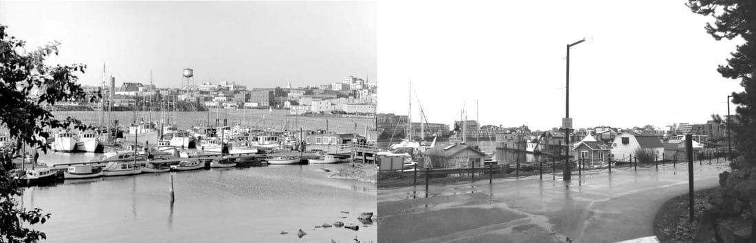
Figure 8: Repeat photograph of Fisherman’s Wharf in 1952 on the left (BC Archives, I-26933 (modified)) and today on the right (Hohendorf, Q.)
.The Wharf provides facilities for boaters and home owners and the sanitary sewers were upgraded relatively recently (Greater Victoria Harbour Authority, 2013). The underground fuel tanks under the parking lot at the west end of the wharf meet “…modern safety and environmental standards” (ibid).
The Wharf gets audited regularly by the Clean Marine BC, a program by the Georgia Strait Alliance (Marina Operations). According to their website, the GVHA’s marinas received a 4 out of 5 “anchor” rating (Marina Operations). The marinas are assessed based on their “fuel and energy use, drainage, water quality, condition of the grounds, water conservation and waste management” (Marina Operations). Island Health, the James Bay Neighbourhood Association and researchers at the University of Victoria Geography Department have been monitoring SO2 levels in the air, concerned about increasing numbers of cruise ships entering the nearby harbour. SO2 levels have decreased steadily over the last years, and air quality guidelines were only “infrequently exceeded” (Setton, 2016).
The Wharf gets audited regularly by the Clean Marine BC, a program by the Georgia Strait Alliance (Marina Operations). According to their website, the GVHA’s marinas received a 4 out of 5 “anchor” rating (Marina Operations). The marinas are assessed based on their “fuel and energy use, drainage, water quality, condition of the grounds, water conservation and waste management” (Marina Operations). Island Health, the James Bay Neighbourhood Association and researchers at the University of Victoria Geography Department have been monitoring SO2 levels in the air, concerned about increasing numbers of cruise ships entering the nearby harbour. SO2 levels have decreased steadily over the last years, and air quality guidelines were only “infrequently exceeded” (Setton, 2016).
|
A popular tourist attraction is the feeding of harbour seals from the wharf (Feeding the seals in Victoria). The DFO is planning on changing the regulations so that feeding of wild animals from the wharf will not be permitted. This is to avoid seals becoming too habituated to human contact and potential danger to humans (Feeding the seals, 2016).
The shoreline is heavily altered compared to its natural state and is almost completely formed by an artificial rock wall. Only east of the wharf, by the corner of Erie St. and Saint Lawrence St. and going north, there are some remnants of natural shoreline. The bay east of the wharf (Heron Cove) has been altered from its natural state but appears relatively natural, with sandy mud flats and dense vegetation (Figure 9). This area is named as an environmentally sensitive area by the City of Victoria Harbour Plan and the Official Community Plan (Greater Victoria Harbour Authority, 2013). According to a former resident who was interviewed by the Times Colonist, Heron Cove has hardly seen any change since he grew up in the neighbourhood in the 1940s and 1950s (Fisherman’s Wharf project evokes Heron Bay memories, 2013). 
Figure 10: The raingarden (Hohendorf, Q.)
|
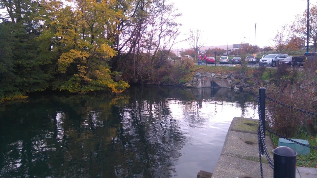
Figure 9: Heron Cove, looking south (Hohendorf, Q.)
Fisherman’s Wharf Park is owned by the City of Victoria and was redesigned in 2010 (Fisherman’s Wharf Park). One of the main changes to the park was the integration of a raingarden. Raingardens collect stormwater runoff from the surrounding areas and retain it for a limited amount of time. They can help to filter out pollutants like oils, chemicals and pet waist before they end up in the ocean (Fisherman’s Wharf Park). The raingarden in Fisherman’s Wharf Park (Figure 10) is the biggest in Victoria with a surface area of 352 square metres (City of Victoria, 2009). It retains the surface runoff from 14,250 square metres of surface (City of Victoria, 2009). The plants used in the garden can tolerate drought in summer and wet conditions in winter (City of Victoria, 2009). Parts of the park contained contaminated material in depths greater than 3 m depth and probably still do in areas where no deep excavation was done as part of the redesign of the park (P. de Greef, Powerpoint slideshow, October 27, 2016). Part of James Bay neighbourhood’s surface runoff is directed through the park into heron cove, only cleaned by a rainwater rehabilitation unit. Since the implementation of the raingarden, about 5 % of the water is filtered before going back into the environment (P. de Greef, Powerpoint slideshow, October 27, 2016). |
The wet conditions offer food and habitat for native birds, insects, and amphibians. I observed hummingbirds and songbirds in the shrubs of the park and seagulls everywhere in the area. There are also cats from the surrounding houses in the park, a potential threat to songbird populations (Beckerman et al., 2007).
A “sandy beach” playground area underlines the recreational intention of the new design. The dune grass originally sparsely planted along the rock wall has grown dramatically and is now covering almost all the sandy beach area (Figure 12).
The raingarden is a perfect example of a novel ecosystem, where several environmental factors like hydrology, species composition, and geology, have been altered to an extend that a return to a natural trajectory is impossible (Hobbs et al., 2009).

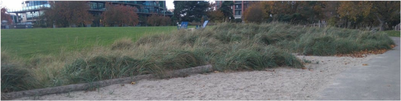
Figure 12: The sandy playground in 2010 (top) (P. de Greef, Powerpoint slideshow, October 27, 2016) and today (bottom) (Hohendorf, Q.)
The original shoreline is represented as a stone wall (Figure 13) embedded in the park’s design and acts as a reminder of the big changes the park has undergone in the last some 150 years.
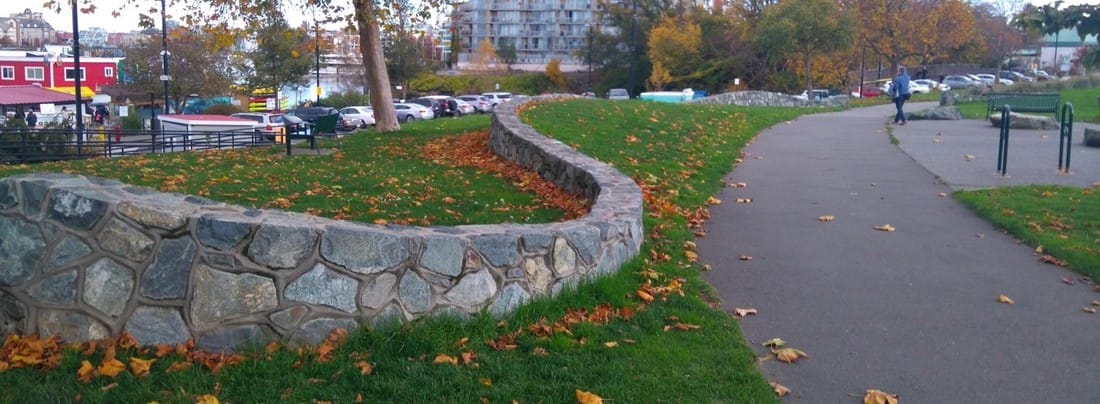
Figure 13: The "Old Bay" wall (Hohendorf, Q.)
Future trajectory
|
In the next decade, the area will be most affected by smaller changes to the wharf. The GVHA plans on increasing the number of commercial floating units and extending the deck plaza area at the east side of the wharf (Greater Victoria Harbour Authority, 2013). A new small area of commercial floating units is planned at the west end of the wharf to attract more visitors (ibid). The GVHA plans to increase the width of the main float which will require a new pedestrian ramp (ibid). The plan also includes the construction of a pedestrian bridge, spanning across Heron Cove as part of the David Foster Harbour Walkway that connects downtown Victoria and Fisherman’s Wharf (ibid) (Figure 14).
The upland section of the wharf property mainly offers access to the wharf and will, according to the wharf plan, not undergo major changes (Greater Victoria Harbour Authority, 2013). The walkway for pedestrians will get expanded in the near future, and there is potential for additional parking at the main entrance (ibid). According to the Fisherman’s Wharf Plan, the main environmental goals for the development are maintenance of the native vegetation in Heron Cove and planting of native plants along the shore (Greater Victoria Harbour Authority, 2013). The Fisherman’s Wharf Park has only recently been re-designed, which makes changes in the coming years unlikely (City of Victoria, 2009). The newly planted trees will grow relatively fast in the coming years and create a canopy cover for parts of the rain garden. The perennial plants in the rain garden will form a denser ground cover, as they mature. If no measures are undertaken, the dune grass will take over all of the sandy area in the park (Figure 12). |
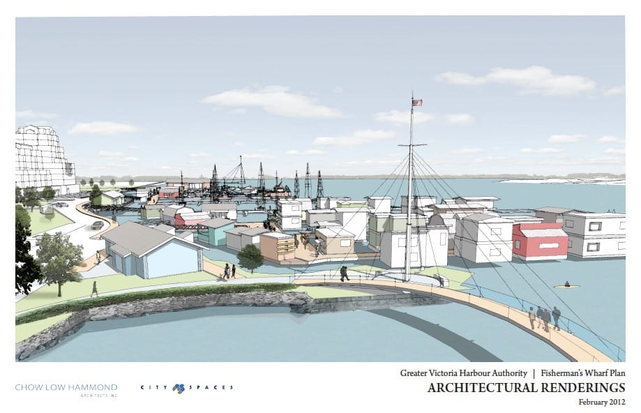
Figure 14: Rendering of the planned pedestrian bridge across Heron Cove (Greater Victoria Harbour Authority, 2013)
Changes will become more significant towards the middle of the 21st century. Temperatures will increase by 1.0 - 2.3 °C by the year 2050 (City of Victoria, 2012). The number of hot days in summer will increase and the summers are predicted to become dryer with up to 32% less precipitation (ibid). On the other hand, winter precipitation is predicted to increase by up to 14% (ibid). Those are significant changes with effects on plant communities in Victoria. In the area around Fisherman’s Wharf most trees are Plane trees, Maple trees, Pine trees, and Cherry trees (personal observation). Cherries already show lower survival rates when replanted (City of Victoria, 2012). Additionally, Victoria’s urban forest cover will decline by 20 % in the next 20 years due to the replacement of over-mature trees (ibid). Changed environmental conditions will increases the risk of invasion by exotic species (Bradley et al., 2010). |
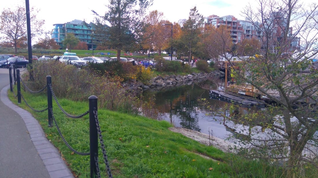
Figure 15: Current shore stabilization, low elevation of the access road and parking lot (Hohendorf, Q.)
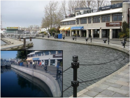
Figure 16: King Tide on Nov 24th 2011 in the Inner Harbour – typical high tide in inset (City of Victoria, 2012)
|
Sea levels will rise by 45 cm by 2050 and by 0.89 – 0.94 m by the year 2100 (City of Victoria, 2012). Storm frequency and intensity are predicted to increase dramatically (ibid). This will affect the risk of flooding and inundation in areas close to the ocean (Figure 3 and 4) (ibid). Most vulnerable to sea level rise are piers and docks, because they are directly affected and access will be increasingly restricted due to flooding and damage to access roads (British Columbia Ministry of Environment, 2013). The Sea level Rise Adaption Primer, by the B.C. Ministry of Environment (2013), suggests four possible adaption strategies to sea level rise: “Protect”, “Accommodate”, “Retreat”, and “Avoid”. I am expecting the City to use a protective strategy since Fisherman’s Wharf is in the centre of Victoria and there is no space to move away from the shore. The access road by the water will be the most important feature to be protected. This will involve an improvement of the existing rocky shore wall, the construction of a sea wall, or relocating the road.
|
In the last 100 years, we have seen a change from a merely industrially used area with chemical industry, but most of its natural shoreline, to an area that is now mainly used for recreation and tourism, with a heavily altered shoreline, a wharf, houseboats, fishing industry and a park that is completely anthropogenic. If we predict a similar change for the next 100 years, Fisherman´s Wharf will look significantly different in the future. It is likely that rising sea levels by about 1 m by 2100 will have the most significant effect on the area in the long term. The land area of Fisherman’s Wharf will be significantly smaller in the future due to a very flat relief of the landscape (Geo BC, 2016) and the wharf may have to be given up. A return to a more natural shoreline seems possible. Maybe the park will be expanded to embed a restored shoreline. Significant changes to the shoreline could be necessary to protect the roads from inundation.
References
Beckerman, A. P., Boots, M. and Gaston, K. J. (2007), Urban bird declines and the fear of cats. Animal Conservation, 10: 320–325. doi:10.1111/j.1469-1795.2007.00115.x
Bradley, B. A., Wilcove, D. S., & Oppenheimer, M. (2010). Climate change increases risk of plant invasion in the Eastern United States. Biological Invasions, 12(6), 1855–1872. http://doi.org/10.1007/s10530-009-9597-y
British Columbia Ministry of Environment (2013). Sea level Rise Adaption Primer, A Toolkit to Build a Capacity on Canada’s South Coast. Retrieved from: http://www2.gov.bc.ca/assets/gov/environment/climate-change/policy-legislation-and-responses/adaptation/sea-level-rise/slr-primer.pdf
Camas Historical Group, (1978). Camas Chronicles of James Bay, Victoria British Columbia. Evergreen Press, Victoria, B.C.
City of Victoria (2009). Fisherman’s Wharf Park Management Plan. Retrieved from City of Victoria website: http://www.victoria.ca/assets/Departments/Parks~Rec~Culture/Parks/Documents/FishermansWharf_Plan_e.pdf
City of Victoria (2012). Risk Assessment of Climate Change Impacts for Victoria Completed: Heat waves, flooding, sea level rise and impacts to natural environment present greatest risks. Retrieved from: http://www.victoria.ca/assets/City~Hall/Media~Releases/2012/120817_MR.pdf
City of Victoria (2012). Summary Report, City of Victoria Completes the First Two Milestones in ICLEI Local Government Climate Change Adaptation Planning Process. Retrieved from: http://www.victoria.ca/assets/Departments/Sustainability/Documents/Adaptation%20Phase%201%20and%202%20Report.pdf
Feeding the seals in Victoria [Web page]. (n.d.). Retrieved from http://www.pgic.ca/feeding-the-seals-in-victoria/ oct 26
Feeding the seals at Victoria tourist hotspot could soon be banned [Web page]. (2016, March 9). Retrieved from http://vancouverisland.ctvnews.ca/feeding-seals-at-victoria-tourist-hotspot-could-soon-be-banned-1.2811067
Fisherman’s Wharf project evokes Heron Bay memories [Web page]. (2013, May 11). Retrieved from: http://www.timescolonist.com/news/local/fisherman-s-wharf-project-evokes-heron-bay-memories-1.176383
Fisherman’s Wharf Park [Web page]. (n.d.). Retrieved from http://www.victoria.ca/EN/main/departments/parks-rec-culture/parks/improvements/fishermans-wharf-park.html
Foster, Harold D. (Ed), (1976). Victoria, Physical environment and development. Western Geographical Series, Vol. 12. University of Victoria, B.C.
Geo BC (2016). Map 092B044 [map], Scale 1:20.000. Retrieved from: http://pub.data.gov.bc.ca/datasets/177864/pdf/092B/092B044.pdf
Goad, Charles E., 1895. Victoria, British Columbia (Fire Insurance Plans) [map], Scale 1:600.
Goad, Charles E., Victoria B.C. http://contentdm.library.uvic.ca/cdm/ref/collection/collection11/id/136
Goad, Charles E., 1903 Insurance Plan of Victoria, British Columbia [map], Scale 1:600.
Goad, Charles E., Victoria B.C. http://contentdm.library.uvic.ca/cdm/ref/collection/collection11/id/98
Goad, Charles E. 1913. Insurance Plan of Victoria. British Columbia. Volume I [map], Scale 1:600.
Goad, Charles E., Victoria B.C. http://contentdm.library.uvic.ca/cdm/ref/collection/collection11/id/216
Grant, Peter, (1995). Victoria, A History in Photographs. Altitude Publishing Canada Ltd. ISBN 1-55153-035-X
Greater Victoria Harbour Authority (2013). Fisherman’s Wharf Plan, Attachment to Rezoning Application to the City of Victoria. Retrieved from http://www.gvha.ca/sites/default/files/pdfs/publications/130523_FishermansWharf_FacilitiesPlan_CityofVictoria_0.pdf
Hobbs, R. J., Higgs, E., & Harris, J. A. (2009). Novel ecosystems: implications for conservation and restoration. Trends in Ecology and Evolution, 24(11), 599–605. http://doi.org/10.1016/j.tree.2009.05.012
Marina Operations [Web page]. (n.d.). Retrieved from: http://www.gvha.ca/environment/marina-Operations
Setton, E. (2016). Sulfur Dioxide Monitoring and Analysis if the Impact of Fuel Sulfur Content Regulation, James Bay, Victoria, B.C. Retrieved from James Bay Neighbourhood Association website: http://www.jbna.org/2015jamesbaysulphurdioxidelevels.pdf
