Geographical and ecological setting
|
Historically, nitrate was pumped into the surrounding riparian forest for treatment. However, this no longer possible: the forests are fully saturated (RLP, 2013). This is problematic since nitrate concentrations are increasing in neighbouring rivers annually, causing lakes to become eutrophic (Burns et al., 2009). Both lakes suffer from multiple sources of runoff; these include wastewater from the City of Rotorua which is located on the Southern Shore, pasture runoff from local agriculture, fluvial system inflows, and geothermal springs (Hwang and LePage, 2011). With the construction of the FTW’s, a wall had been built in Lake Rotoiti to divert its nutrient-rich waters through the Ohau channel to Lake Rotorua for filtration before entering the Kaituna River as result (De Winton et al., 2013).
Lakes Rotorua and Rotoehu use aquatic plants in buoyant mats to manage nutrient concentrations in surrounding waters (Fig. 1; Burns et al., 2009; Tanner et al., 2011). These Lakes form two of the world’s largest FTW’s, both of which have an overall goal to improve water quality (RLP, 2013). The ecological purpose of these FTW’s include: 1) Creating surface area for plant roots to grow into the water column underneath anchored islands, 2) Use plants for nutrient assimilation, 3) Promote a sustainable habitat for biofilm construction, and 4) Create a network of plants that will filter suspended particulates within the water column (Tanner et al., 2011). The ecological ingenuity of this approach is considerable; with plants not being rooted within soil, they are forced to acquire nutrients from the water column (Fig. 2). It allows for constant uptake of nutrients that continually flow into each lake with minimal management (Hwang and LePage, 2011). With the ability to be anchored in areas nutrient density, both FTW’s were initially used as treatment for wastewater in eutrophic lakes to mitigate their adverse effects (De Winton et al. 2013; RLC 2014). Lake Rotorua (80.8 sq. km, 45 m max depth, 11 m average depth) has the largest FTW. This FTW was created from over 364,000 plastic bottles that were re-purposed into floating mats. Within these mats, 20,000 indigenous plant were sewn in (RLC, 2014). These plants were chosen for their capabilities to uptake the nitrogen and phosphorous from the surrounding waters, which ultimately were reduced over time post-implementation of FTW’s (Fig. 3). The FTW’s serve more than one purpose; they create nursery habitats for koura (i.e. endemic freshwater crayfish), nesting sites for birds, help revitalize fisheries by removing toxins and fostering prey species, and act as barriers to reduce wave force on shores to fight erosion (RLP, 2013). Likewise, the FTW on Lake Rotoehu –(8 sq. km, 13.5 m max depth, 8 m average depth) was also created in a similar manner to Lake Rotoura. Before FTW implementation, Lake Rotoehu suffered from nitrogen limitation, which led to chronic cyanobacterial blooms. These blooms were potent; they created conditions that were conducive to the rise of the large beds of hornwort (Ceratophyllum dermersum) that now exist and outcompete other species for habitat space (Burns et al., 2009). This take-over resulted in a decrease in local biodiversity, which ultimately destabilized Lake Rotoehu’s ecological integrity (MacGibbon et al., 2010). Interesting geothermal features within both lakes have helped support a large diversity of multi-trophic freshwater organisms being found within both lakes (Burns et al., 2009). Using mesocosms on Lake Rotoehu, managers learned to control the harmful cyanobacterial blooms to allow for this diversity to thrive (Fig. 3; Tanner and Headley, 2008). Similarly in Lake Rotorua, macrophyte establishment and survival were found to significantly have improved alongside increased mussel densities (De Winton et al. 2013). These results have been attributed due to the following FTW effects: 1) Nitrate conversion to nitrogen gases through denitrificaiton, 2) Enhanced productivity due to anoxic areas localized beneath mats, and 3) Large filtering-out of nutrients that enhance algal growth (Tanner et al., 2011). |
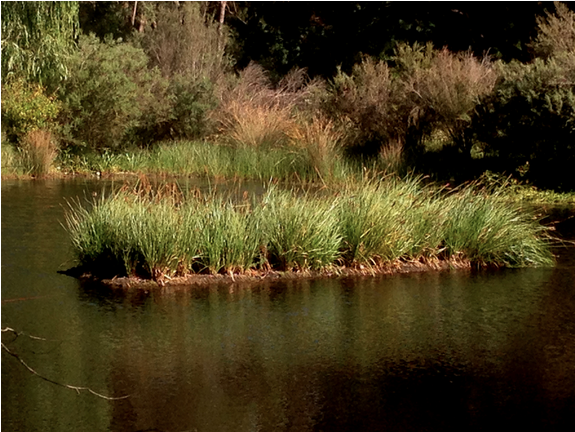
Anchored FTW exhibiting its aesthetic value. Image was taken before planting of indigenous species.

Lake water turning green due to eutrophication.
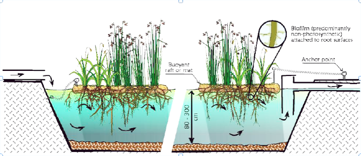
FTW assemblage showing particulate filtering mechanism (Tanner and Headley, 2011).
|
