Songhees Point and Westsong Walkway: A Transformed Landscape
Erika Carney
Summary
Here I look into the distant and not-so-distant history of the culturally and economically salient site known as Westsong Walkway and Songhees Point. Through my search I look at the past ecology and human presence on the landscape. Especially, I look at the substantial anthropogenic re-shapings of this site after European settlements. I then examine its present state including its uses, characteristics, and the ecological and social effects of re-shapings. This includes water contamination, habitat loss, commercialization and degradation of a culturally important site. Lastly, through my research, I predict the potential future trajectories of the site so as to consider whether and how the landscape will be altered (Figure 1). |
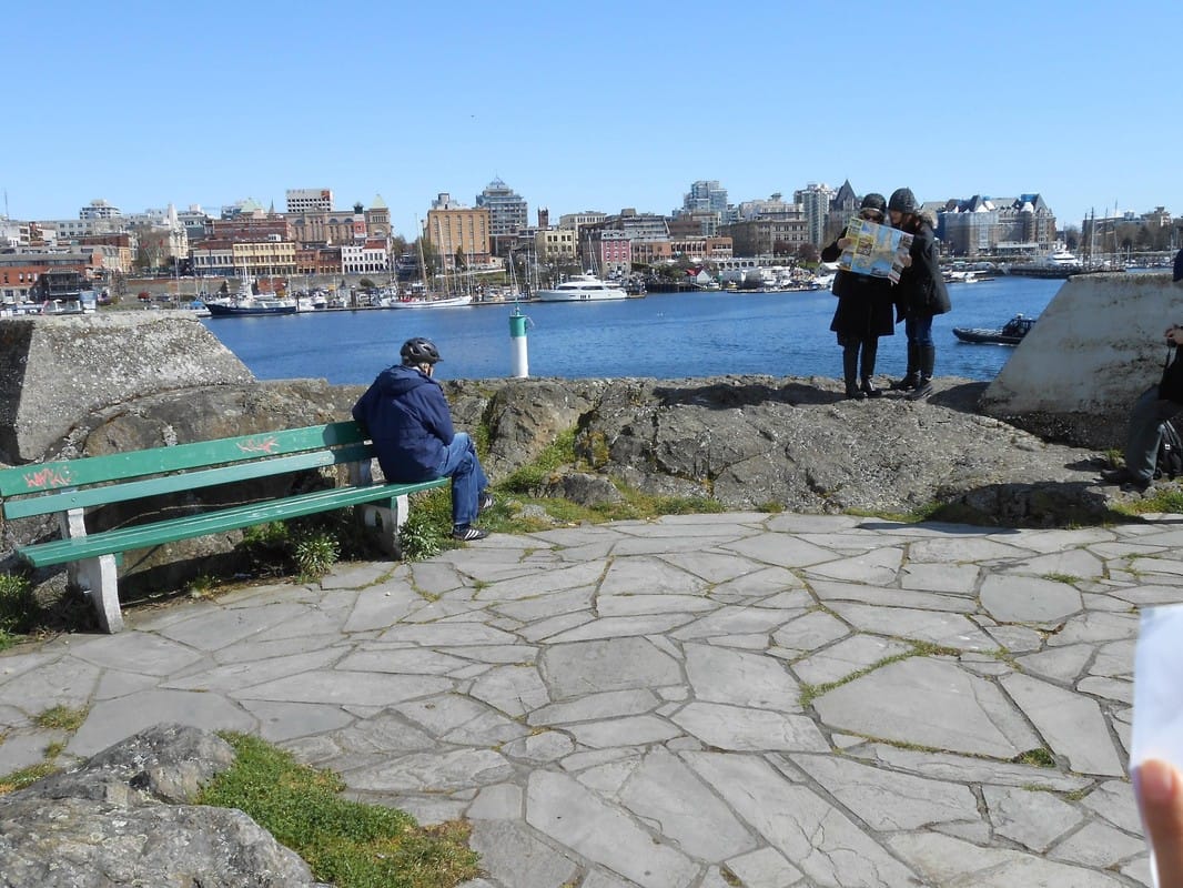
Figure 1, Songhees Point, Erika Carney
|
Genealogy
|
The site is located along the southwest edge of Victoria’s Inner Harbour in what was once known as the Old Songhees Reserve (Songhees – Old Songhees Reserve, n.d). This boundary extends from the Johnson Street bridge along the Westsong Walkway and into Lime Bay Park.
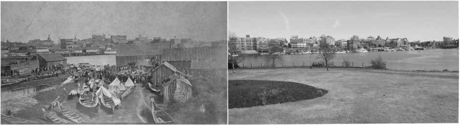
Walking along this landscape, it is evident that it has been highly transformed with paved walkways and various lookout points. Despite its present state, this landscape was once an important trading port for the Esquimalt and Songhees First Nations. As settlement began in Victoria’s harbour, some of the Songhees Nation located themselves in the Inner Harbour because of the trading opportunities it provided (Songhees – Old Songhees Reserve, n.d). In the online Saanich archives I was able to find a photograph from 1895 entitled “First Nations Potlatch, Songhees” (Figure 2). Years after this photo was taken, the reserve was forcefully relocated to the West side of Esquimalt (Songhees – The Esquimalt Reserve, n.d). 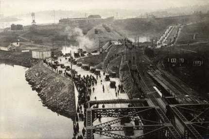
Figure 3: “Traffic lined up in Victoria West on opening day of the Johnson Street Bridge January 11, 1924 – (City of Victoria Archives M00353)”
http://www.johnsonstreetbridge.com/new-bridge/history/
|
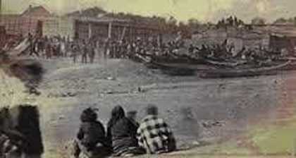
Figure 2: In view is what became the Old Songhee Reserve. By the water, there is a large Potlatch being held despite the fact that they had been banned several decades earlier (Joseph, 2012)– 1895
http://www.saanich.ca/EN/main/parks-recreation-culture/archives/search-photos.html
The reasoning behind this relocation was the fact that Victoria settlers saw the First Nation’s location along the harbour, a place of economic potential, as a hindrance to the future progress of Victoria (Banivanua-Mar, T., Edmonds, P, 2010). This relocation had a drastic effect on the cultural landscape of the inner harbour as it went from a place heavily laden with traditions and indigenous values to a predominantly industrial and commercial site with Eurocentric values. In 1920, following the displacement of the Songhees Reserve, a roofing company started up along the harbour (Trachsel, 2004). Later, in 1924, the city of Victoria built the Johnson Street bridge in order to facilitate movement between Victoria’s main city and the newly industrialized area (Figure 3) (Trachsel, 2004). In 1992 a large hotel was built near the Johnson Street Bridge called the Delta Ocean Pointe Hotel (Delta Ocean Pointe Hotel, personal communication, Dec 5, 2016).
I was able to find a photograph of paintings done in the late 1800’s of my chosen site (Figure 4) (Wonders, n.d). This painting depicts a landscape with rolling, grassy bluffs. The |
trees look like Douglas firs and Garry Oaks. This assumption is influenced by prior knowledge of the First Nation’s fire management techniques. This type of management results in a meadow-like landscape which is characteristic of Victoria. According to archeological findings, indigenous peoples had lived in this area for over 4,000 years prior to European settlement (Dunae, P. A., Newcomb, J, and Forward, C.N, 2011). This painting provides a nuanced way of understanding what this site once looked like, though this archival record proves difficult to identify the vegetation with total accuracy, especially the understory.
Although there is a rather robust account of the Inner Harbour’s post-settlement history, information concerning the landscape’s geography before the arrival of Europeans and First Nations was less accessible. In fact, there was a general lack of First Nation’s documentation. This might have a lot to do with their predominantly oral culture but might also have to do with the European settler’s resistance to legitimizing indigenous knowledge.
Although there is a rather robust account of the Inner Harbour’s post-settlement history, information concerning the landscape’s geography before the arrival of Europeans and First Nations was less accessible. In fact, there was a general lack of First Nation’s documentation. This might have a lot to do with their predominantly oral culture but might also have to do with the European settler’s resistance to legitimizing indigenous knowledge.
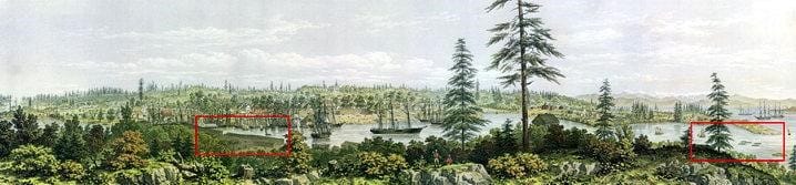
Figure 4: A lithograph of the Old Songhee Reserve, Day & Son, Lithographers to the Queen, 1860
http://www.firstnations.de/development/coast_salish.htm
Socio-ecological characterization
I was able to recreate a photo of the old Songhees. Repeat photography is a valuable tool in recognizing the social, political, and geographical changes that have occurred on this and another landscape.
The geography of this landscape is composed of several plant and wildlife species, though the abundance of terrestrial species is limited due to habitat loss and fragmentation in the urban setting (Figure 5). Therefore, a majority of the site consists of disturbed zones of vegetation and “boulevard trees” (Environmental Assessment Report, 2010). Vegetation such as Douglas Fir, Garry Oak, Indian plum, Alaskan oniongrass, baldhip rose, and many butterfly and caterpillar species are all present in this site (Environmental Assessment Report, 2010).
The Inner Harbour is also well known for its bird populations, and, the site is part of a migratory bird sanctuary. Key bird species include Canadian geese, pelagic cormorant, mergansers, dabbling ducks, shorebirds, loons, grebes and glaucous winged gulls (Victoria Harbour Migratory Bird Sanctuary, 2016).
Subtidal habitats comprise a large part of the landscape. Some species include spot prawns, dungeness and slender cancer crab, kelp, algae, barnacles, mussels, seals, seastars, and tube worms, along with fish populations such as saddleback gunnel, shiner perch, striped seaperch, lingcod and salmon (Environmental Assessment Report, 2010).
Victoria’s harbour receives currents from the Strait of Juan de Fuca, though the tidal flow on this particular shoreline is less intense. However minimal, these currents are vital to the health of marine life as they mix and transport nutrients, gas, and oxygen throughout the ocean (Local Currents, n.d).
This site was once a rocky shoreline has since been converted through paving, filling, and the installation of sewage systems (Lime Bay Park, 2014). However, much of the shoreline has remained in a semi-natural state with rock outcroppings and a sedimentary shoreline along Lime Bay Park (Lime Bay Park, 2014). At low tide, the shoreline dries to reveal a mudflat, rich with intertidal species such as starfish, rockweed and sea lettuce (Lime Bay Park, 2014). In comparison to the rest of Victoria’s coastline, the effects of erosion on this site are negligible, however, there is a heavily modified rock wall along the front of the Delta Ocean hotel which, due to the nature of the structure, decreases marine habitat potential. (Brian, 1984). Along with the effects of shoreline modification, marine life has been hit heavily by water contamination over the past century due to the harbour’s polluting activities (Environmental Assessment Report, 2010).
This site, which is part of Victoria West, was once owned by the Hudson Bay Company but is currently owned and managed through the City of Victoria. The Capital Regional District (CRD) and the British Columbia government also own a portion of the land (What is CRD, n.d). Finally, the harbour waters are mainly managed by the Federal Government and there is some private ownership (Overview & History: Victoria's Harbour, n.d). Although there are many distributions of ownership, The City of Victoria provides waste, water, and disaster management, transit, parks, and electricity services, and area planning for this area (Municipalities, n.d).
Years after the removal of the Songhees First Nations from this site, the land was known for its industrial use. Looking back through city plans during the late 1900’s, one can see that the trajectory of the land was highly contested. This is because,at that time, its status as a transitional industrial zone contrasted with what the community saw as a site with the potential to be a commercial area, similar to the other side of the harbour (Greenhalgh, 1972).
Future trajectory
This site is influenced by several pressures. Its influences that will likely have an affect on its future trajectories are diverse and include market and urban development interests, an interest in preserving a culturally significant area of the Songhees peoples, and an interest in restoring ecological connections. Therefore, I can imagine this site following several different trajectories.
|
Through these past few decades, there has been deliberate push towards more commercial interests and this trend will most likely continue for several decades to come. I make this assumption for several reasons: firstly, the Johnson Street Bridge Replacement project’s goals are heavily focused on creating more bicycle and pedestrian access in order to promote tourism and recreational use of the area (City of Victoria: Johnson Street Bridge Replacement Project, n.d). Secondly, the RailYards waterfront community, located just north of the Johnson Street bridge, will soon be completed and will most likely increase the popularity of this area, creating demands for new infrastructure (The RailYards, n.d). Lastly, the new Victoria International Marina, which will be available for the docking of luxury yachts, is in the beginning stages of development (Thomas, 2016). This 24-million-dollar project will sit just south-east |
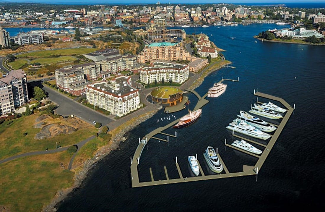
Figure 6: Victoria International Marina http://vibrantvictoria.ca/forum/index.php?/topic/1406-vic-west-victoria-international-marina/page-87
|
of Songhees Point. Although it is projected to inject around $800,000 into the local economy, most people who use the harbour for non-motorized transportation such as kayaks and SUP’s are opposed to this project’s development (Figure 6) (Thomas, M, 2016).
Along with acknowledging the opposition felt by some of the community towards this development, it is also important to acknowledge the opinions of the First Nations Songhees who recognize this land as a sacred and culturally significant site (City of Victoria: Signs of Lekwungen, n.d). This land is protected under the Heritage Conservation Act (HCA) and is Coast Salish unceded territory. It is a significant site to the Songhees peoples, not only because of its history as a major trading port during settlement, but also for its sacred value. Traditionally, the community would bring their children’s cradles to this site under the belief that the waters held spiritual powers (City of Victoria: Signs of Lekwungen, n.d). Because of this, the First Nations artist Butch Dick, in collaboration with the City of Victoria, chose Songhees point, along with six other sites, for the art piece entitled “Signs of Lekwungen” (City of Victoria: Signs of Lekwungen, n.d) (Figure 7).
Along with acknowledging the opposition felt by some of the community towards this development, it is also important to acknowledge the opinions of the First Nations Songhees who recognize this land as a sacred and culturally significant site (City of Victoria: Signs of Lekwungen, n.d). This land is protected under the Heritage Conservation Act (HCA) and is Coast Salish unceded territory. It is a significant site to the Songhees peoples, not only because of its history as a major trading port during settlement, but also for its sacred value. Traditionally, the community would bring their children’s cradles to this site under the belief that the waters held spiritual powers (City of Victoria: Signs of Lekwungen, n.d). Because of this, the First Nations artist Butch Dick, in collaboration with the City of Victoria, chose Songhees point, along with six other sites, for the art piece entitled “Signs of Lekwungen” (City of Victoria: Signs of Lekwungen, n.d) (Figure 7).
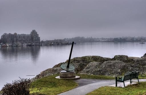
Figure 7: Signs of Lekwungen, Butch Dick, http://artsvictoria.ca/butchdick
In terms of this site’s potential ecological trajectory, it is important to recognize it as a novel ecosystem (Hobbs, R. J., Higgs, E., & Harris, J. A., 2009). This is because it has passed a certain threshold making its return to a “traditional” state impossible. In “Biodiversity in Greater Victoria”, this space is classified as being a commercial/industrial zone with limited space for organisms and even less so for native species (Schaefer, 1993). It has been so heavily altered by human activity that it performs very few ecosystem functions and has incredibly low biodiversity levels (Schaefer, 1993). On top of these factors, this specific area has received little attention and environmental concern from the community of Victoria in contrast to more heavily degraded sites such as Rock Bay and Ogden Point (Schaefer, Miles, 2013). Therefore, restoration of any kind on this site seems intractable. However, with examples such as Dockside Green, which show the potential of designed ecosystems on urban landscapes, hope for engagement in this area should not be abandoned. The framework for Dockside Green is a simple and effective
|
Increased recognition of indigenous land rights in Canada lead me to have hopes for the future in areas such as land reform. I hope that we can acknowledge Indigenous communities as unique nations under self-governance and, in doing so, create a legal situation where both the First Nations of the community and the Provincial government have shared power over the land. If this transition is made in the future, it might not only have an affect on the future trajectory of the landscape, but it might also have an affect on the overall health of the Songhees community (Bryce, 2007). Even if this transition has no visible effect on the ground, I still feel it is crucial in respecting the Songhees cultural connection to the land by allowing them choice when dealing with the future of this site (Indigenous Peoples - Lands, Territories and Natural Resources, n.d). 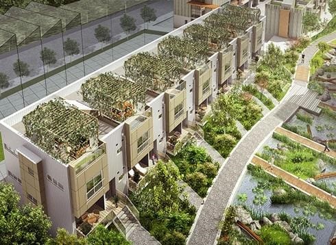
Figure 8: Dockside Green Infrastructure
https://www.pinterest.com/pin/533746993308592738/
|
way of creating smart infrastructure that engages the community and encourages ecosystem functions (Figure 8) (Schaefer, Miles, 2013).
There is no question that this landscape will change over time as it has done so drastically over the years, therefore, there should be emphasis put on greener infrastructure for the future. Simple steps should be taken similar to Dockside such as the implementation of permeable surfaces as well as other ideas such as edible landscape gardens. Perhaps, with this as a stepping stone, larger scale infrastructure changes can become more feasible such as the softening of the shoreline along the hotel in order to promote intertidal habitats and the creation and management of larger green spaces and pathways.
There is no question that this landscape will change over time as it has done so drastically over the years, therefore, there should be emphasis put on greener infrastructure for the future. Simple steps should be taken similar to Dockside such as the implementation of permeable surfaces as well as other ideas such as edible landscape gardens. Perhaps, with this as a stepping stone, larger scale infrastructure changes can become more feasible such as the softening of the shoreline along the hotel in order to promote intertidal habitats and the creation and management of larger green spaces and pathways.
References
Banivanua-Mar, T., Edmonds, P. (2010). Making Settler Colonial Space: Perspectives on Race, Place and Identity. London: Palgrave Macmillan.
Bryce, C. (2007). Heritage Conservation Act Or Heritage Destruction Act. N.p. Web. 8 Nov. 2016. http://www.firstnations.de/media/06-1-1-bryce-2.pdf
City of Victoria. (n.d). Johnson Street Bridge Replacement Project. N.p. Web. Oct 28. 2016 http://www.johnsonstreetbridge.com/public-involvement/plazas-pathways-public-spaces/
City of Victoria. (n.d). Johnson Street Bridge Replacement Project: Plazas, Pathways & Public Spaces. N.p. Web. Oct 28. 2016 http://www.johnsonstreetbridge.com/public-involvement/plazas-pathways-public-spaces/
City of Victoria. (n.d). Signs of Lekwungen. N.p., 2016. Web 10 Nov. 2016 http://www.victoria.ca/assets/Departments/Parks~Rec~Culture/Culture/Documents/arts-lekwungen-brochure.pdf
CRD. (2014). Environmental Concerns. N.p., Web. 14 Oct. 2016.
CRD. (n.d). Local Currents. N.p. Web. 28 Oct. 2016 https://www.crd.bc.ca/education/our-environment/geology-processes/local-currents
CRD. (n.d). What is CRD. N.p. Web. 20 Oct. 2016 https://www.crd.bc.ca/about/what-is-crd
Dunae, P. A., Newcomb, J,. and Forward, C.N. (2011). Victoria (BC). The Canadian Encyclopedia. Historica Canada C.M,. Web. 13 Oct. 2016.
Government of Canada, Environment and Climate Change Canada. (2016). Victoria Harbour Migratory Bird Sanctuary. N.p. Web. 28 Oct. 2016.
Greenhalgh, G. J. (1972). Victoria West. Department of Community Development. City of Victoria.
Greater Victoria Harbour Authority. (n.d). Overview & History: Victoria's Harbour. N.p. Web. 20 Oct. 2016 http://www.gvha.ca/about-gvha/overview
Healthy Naturalist: Walks in Your Backyard, Wherever You Live. (2014). Lime Bay Park. N.p. Web. 20 Oct. 2016 https://healthynaturalist.wordpress.com/2014/05/21/lime-bay-park/
Hobbs, R. J., Higgs, E., & Harris, J. A. (2009). Novel ecosystems: Implications for conservation and restoration. Trends in Ecology & Evolution, 24(11), 599-605. doi:10.1016/j.tree.2009.05.012
Indigenous People Indigenous Voices. (2016). Indigenous Peoples - Lands, Territories And Natural Resources. N.p. Web. 11 Nov. 2016. http://www.un.org/esa/socdev/unpfii/documents/6_session_factsheet1.pdf
Johnson Street Bridge Replacement Project. (2010). Environmental Assessment Report. Stantec. Web. 28 Oct. 2016.
Joseph, B. (2012) Potlatch Ban: Abolishment of First Nations Ceremonies: Working Effectively with Indigenous Peoples. N.p., 16 Oct. 2012. Web. 14 Oct. 2016.
Local Government Department: Ministry of Community, Sport & Cultural Development. (n.d). Municipalities. N.p. Web Oct. 20. 2016
http://www.cscd.gov.bc.ca/lgd/pathfinder-mun.htm
Schaefer, V., 1951., Douglas College. (1993). Biodiversity in Greater Victoria. Douglas College, New Westminster, B.C
Schaefer, V., 1951., Jessica M., 1986., University of Victoria (B.C.). (2013). Restoration Walks in Victoria: A Guide to several Ecological Restoration Projects in Greater Victoria. BC, Restoration of Natural Systems Program, School of Environmental Studies, University of Victoria, Victoria, BC.
SpringTide Whale Watching & Eco Tours. (2014). Marine Wildlife in Victoria, BC: What's Out There Other Than Whales? Leap XD. Web. 20 Oct. 2016 https://www.victoriawhalewatching.com/2014/09/07/marine-wildlife-in-victoria-bc/
The RailYards. (n.d). The RailYards Development. N.p. Web. Nov 10. 2016 http://www.therailyards.ca
Thomas, M. (2016). Have A Super-Yacht? You Could Soon Park It In Victoria's Harbour. CBC News. Web. 10 Nov. 2016. http://www.cbc.ca/news/canada/british-columbia/super-yacht-marina-under-construction-in-victoria-1.3790988
Thunderbird Park: Place of Cultural Sharing. (n.d). Songhees - Old Songhees Reserve. N.p., Web. 14 Oct. 2016.
Thunderbird Park: Place of Cultural Sharing. (n.d). Songhees - The Esquimalt Reserve.. N.p. Web. 14 Oct. 2016.
Trachsel, J. (2004). Victoria Heritage Foundation: Vic West History. Victoria Heritage Foundation: Vic West History. N.p. Web. 13 Oct. 2016.
Wonders, K. (n.d). Coast Salish. First Nations: Land Rights and Environmentalism in British Columbia. N.p. Web. 13 Oct. 2016.
Webster, B. (1984) The Development and Planning of the Inner Harbour Area of Victoria, British Columbia. MA thesis, University of Victoria.
