A Model for Integrated Social Ecologies on University of Victoria Campus
Alex Campbell & Matt Kemp
Summary
This paper analyzes the area currently known as the University of Victoria (UVic) campus in Victoria B.C., exploring the historical and modern pressures that have shaped the landscape into what we see today. With a rich history of indigenous, agricultural, military, and educational uses, this area has been highly altered with ecological thresholds pressured towards novel regimes, yet many sections of campus are still considered hybrid systems. The focus of this paper is on the area inside of Ring Road, recognized as a novel ecosystem due to the effects of development and fragmentation, which have altered the composition and functionality beyond the restoration threshold, reinforced by disrupted hydrologic cycling due to large areas of impervious surface. |
|
UVic also features a myriad of social and political pressures that have directed and expanded the university based on aesthetic, structural, and sustainable components. These standards have produced an impressive university, but looking forward involves the university to start integrating social and ecological components to compliment the natural areas still on campus. Fortunately, recent installations have improved stormwater infrastructure and the construction of buildings under LEED gold certification have made big strides in sustainable development, and we felt driven to complement these structures with intriguing edible ecology features. Our proposed trajectory seeks to promote social-ecological connectivity by creating meaningful spaces that facilitate engagement on campus with creative agro-ecology. Consequently, the aim of this project is to install a series of interactive art and educational features within an edible garden design network; the result is expected to promote engagement amongst visitors on campus, while enhancing green-spaces within a diverse web of connective habitats. Considering the educational applications, the Environmental Studies and Restoration of Natural Systems programs have the potential to gain significant benefits through the enhancement of natural spaces.
Genealogy
Up until approximately 12,000 years ago, southern Vancouver Island was covered in the Cordilleran ice sheet, which began receding due to climatic shifts and gave rise to the landscape we see now (Shugar et.al, 2014). This was the time of the Pleistocene era, characterized by major environmental shifts including changes in sea level, earthquakes and volcanic eruptions (Turner, 1947). Many of the native plant species on Vancouver Island began to propagate after the Pleistocene during the Holocene era, beginning around 10,000 years ago as pollen records display a clear warming trend that brought more drought tolerant species to Vancouver Island that paired with a noted increase in the frequency of fires (Turner, 1947). Douglas-fir (Pseudotsuga menziesii) forests were prominent with smaller patches of Garry oak (Quercus garryana) savanna interspersed- which would have included traditionally managed camas (Camassia) meadows (Turner, 1947). Interestingly, this was also a time that saw species migrate to Vancouver Island from the southern regions, such as arbutus (Arbutus menziesii), salal (Gaultheria shallon), and evergreen huckleberry (Vaccinium ovatum) (Turner, 1947). As the Holocene era progressed, pollen records indicate cooler and moister climates became more prevalent and environmental conditions allowed for the conifer-dominated forests to diversify and spread with emerging Western red-cedar (Thuja plicata) trees (Turner, 1947). Within a moist maritime climate, the forests during this time closely resembled the Coastal Douglas-fir (or CDFmm) ecosystems we see today on southern Vancouver Island. These favorable climatic conditions allowed early indigenous communities to stay in the area and begin to implement traditional management techniques to further improve yields (CRD, 2016; Turner, 1947).
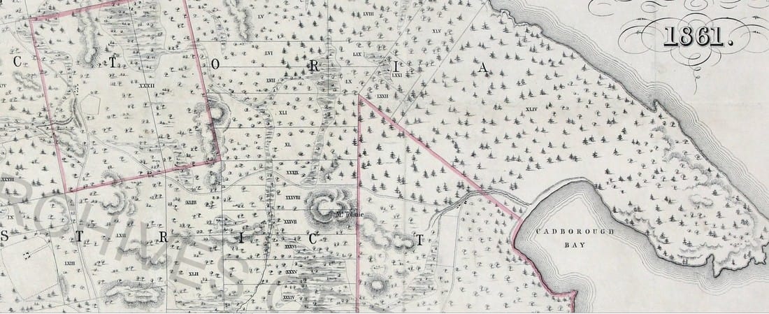
Figure 1: Settler map developed by Day & Son lithographers in 1861 that shows subdivided lands (black lines) and municipal borders (pink lines); topography and hydrography are represented- as well as dominant tree species, to show areas of Douglas-fir forests or Garry-oak meadow.
|
The WS'ANEC' (Saanich) nation has called the Saanich peninsula home since time immemorial, with their traditional lands extending into Gordon Head where the University of Victoria is situated today (Horne, 2012); the area was also frequented by Lkwungen (Songhees) and Wyomilth (Esquimalt) nations. SI CENEN, also known as Gordon Head, translates into “becoming Saanich” and it was an area of ethnobotanical importance to the WS'ANEC' nation, used to gather different foods and medicines, to hunt and to gather seafood by the ocean (Horne, 2012). In turn, various active management techniques enabled traditional peoples to help shape the environment around them; burning, coppicing, and selective harvesting are all examples of how the ecosystem would have evolved with human actions (Horne, 2012). Eventually, Vancouver Island and the Saanich peninsula saw colonization in full force with relationships changing from trade of material goods to that of acquiring and developing land (Horne, 2012). In 1850, the Douglas Treaty process began with devastating effects for the various indigenous groups in the area. While hunting and fishing rights were protected to a certain extent, the indigenous nations lost control of a large portion of their traditional territory (Horne, 2012); as a result, the traditional practices and local environments began to change drastically due to the colonization and assimilation.
|
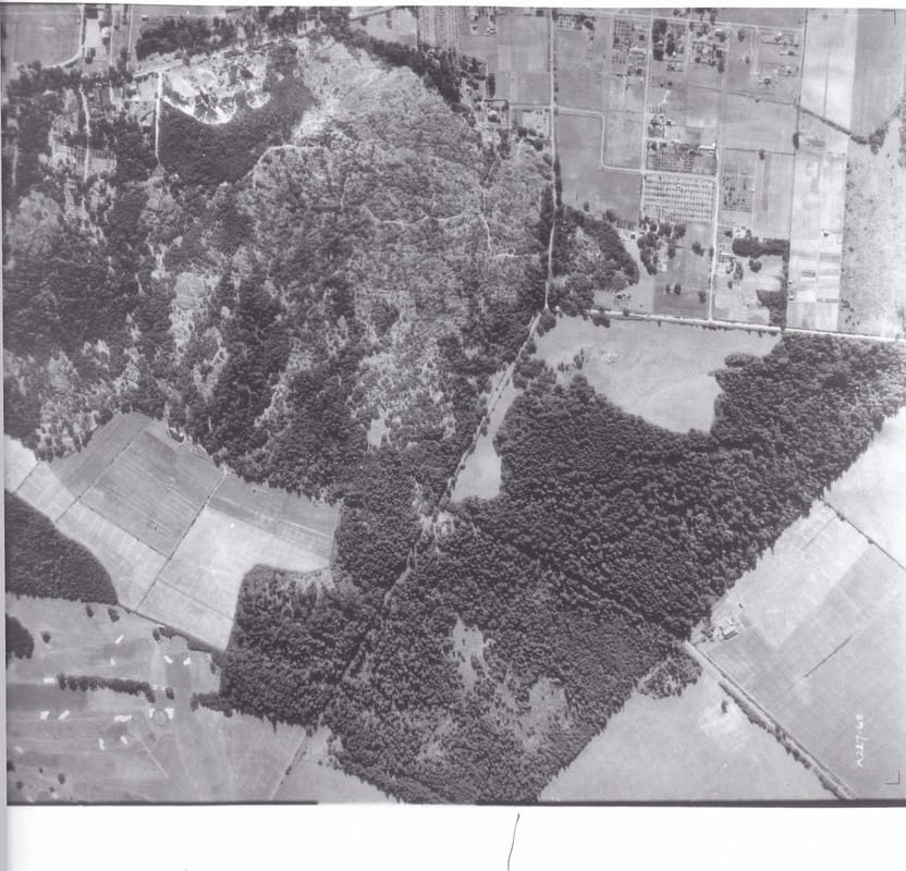
Figure 2: Airphoto from 1928 showing Mount Tolmie, and the roads currently known as Cedar Hill X-rd and Gordon Head rd. Bottom right shows the pronounced tree-line that follows the Oak Bay/Saanich border. Bottom left shows Uplands golf course.
|
The first settler to cut into the raw forests that once sat within University of Victoria boundaries was an irishman by the name of Michael Finnerty, who bought a total of 330 acres from John W. Mckay & John Works in 1871 (Jupp, 1975). At the point of purchasing the land, Michael noted thick old-growth stands of Douglas-Fir forests that extended to the ocean along with what we know to be Cedar Hill Cross-road (previously Bay rd.), and got to work clearing sections for a cow pasture (eventually sustaining around 50 cows) while building himself a family home (Jupp, 1975). The map of the area from 1861 (see visual 1) vaguely differentiates between predominantly Douglas-fir, Garry Oak, or wetland areas allowing us to understand what some of the landscape looked like when Finnerty arrived; one can correlate this with the patches of Douglas fir forests left in 1928 (visual 2) to see the density of those forests and the fragmentation that was already evident early in the 20th century (University of Victoria). From the same airphoto, it is also clear that the border between Saanich and Oak Bay was very pronounced and showed minimal eco-tone between the forest and the pasture. As a result, we can expect that the university grounds have been significantly altered since being cleared for pastures, and this disturbance compromised the integrity of the forest by confining dynamic habitats and processes.
During the late 19th and early 20th century, Finnerty worked the land with the help of his wife and three children on Spring Bank Farm, renowned for its creamy milk (Jupp, 1975). In addition, Michael was known locally for his incredible vitality, which he claimed was thanks to the curative powers of the waters on Spring Bank Farm, likely referring to Hobbs Creek or Bowker Creek (Jupp, 1975). Finnerty continued to work on the land until retiring in 1911 and selling the majority of his acreage for subdivision in the midst of the 1910 land boom (Jupp, 1975); this was happening throughout the area, as can be seen in visual 3. The property passed through a series of hands until about 1930 when it was abandoned in the calm before World War II (Jupp, 1975). In conclusion, the occupation of raising cattle and various farming operations previously maintained hydrologic function, but modified the understory significantly through trampling, grazing, and spreading manure; these pressures would have served as the first step towards a novel ecological regime on the property.
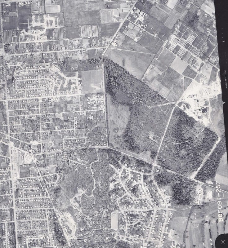
Figure 3: Airphoto from 1964 showing further subdivision of neighbouring farmlands, as well as the development of Ring rd at left middle of photo; also note signs of pronounced forest boundaries and significant development around Mount Tolmie.
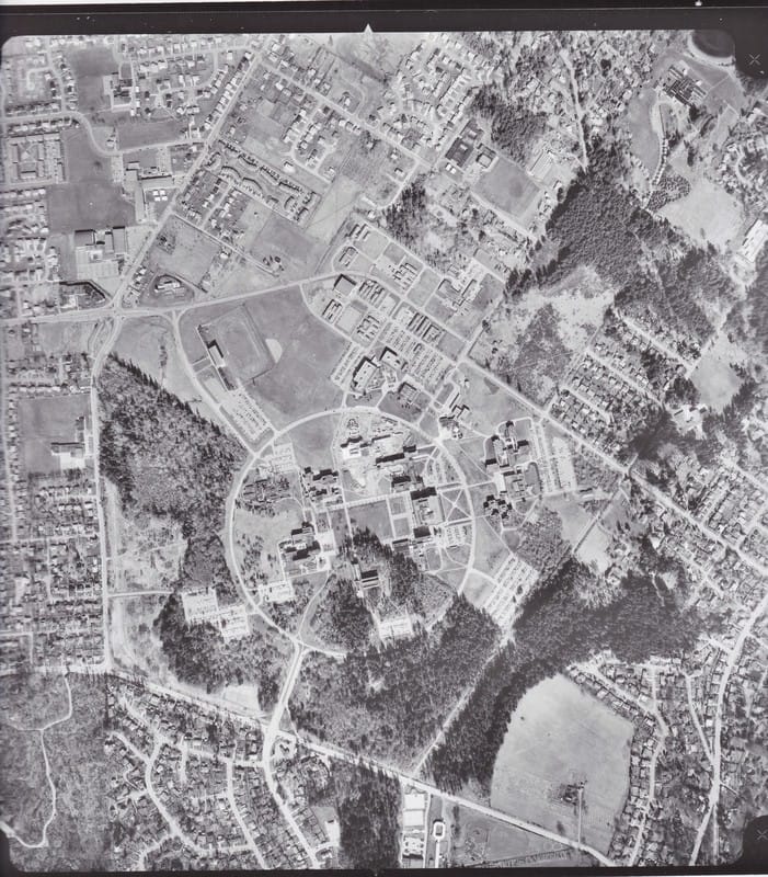
Figure 4: Airphoto from 1977, showing the completion of Ring rd and the amount of forest disturbance required to do so. This image also shows the expansion of University buildings that expanded to delineate the property we recognize today.
|
Soon the region saw more external pressures in a different era of development, including an airfield which brought two runways and a hanger to the rural, agricultural, and forested landscape of Gordon Head in 1931 (Lovell & Turner, 1999). Prior to WWII the area was used by the military as a signal station until the war broke out and this landscape was turned into a training camp(Lovell & Turner, 1999). By 1959, the wartime efforts were receding and the University Development Board purchased the Gordon Head army camp from the federal government, including the adjacent forested lands from the Hudson Bay Company (Lovell & Turner, 1999). Construction of the university began in 1962 with only a handful of buildings by 1964; this only affected the area previously cleared for the army base and agricultural land (Lovell & Turner, 1999). The forested area purchased from the Hudson Bay Company still remained largely intact, however by 1975 there was clear evidence of expansion as the majority of campus buildings had been constructed (see visual 4); the forest area has now significantly reduced in size and been degraded by anthropogenic impacts such as fragmentation, hydrologic disruption, and introduced species.
Through analysis of the written and pictorial history from the site of UVic campus, we know it was previously a densely and diversely populated CDFmm rainforest previously co-inhabited by indigenous groups until colonized by Europeans. These early indigenous communities practices various land management regimes within the local ecosystems over many generations to foster greater abundance and biodiversity. When Europeans colonized the area, many of these management techniques were not allowed to continue, severing many ethnobotanical patterns as Europeans began developing the area. These, among other continued factors and pressures, have led to its emergence as a heavy transformed novel ecosystem (Flynn, 1999; CRD, 2016). After losing many endemic species and essential connections through fragmentation and land alteration, one can be confident that a large percentage of the area within Ring Road is past the restoration threshold for its historical state. However, it’s place within a university environment allows analysis, education, and application to mobilize efforts that reinforce learning material whilst building adaptive capacity within the local socio-ecosystem, especially if agroforestry and edible landscapes can be put in place. It is important to note that there are a few fragmented natural areas within Ring Road that have not crossed the restoration threshold and are undergoing recolonization of native plants; an example of this is Cunningham Woods. These spaces can see significant improvements with the mobilization of time and resources, and by facilitating |
connectivity between adjacent ecosystems, such as South Woods and Finnerty Gardens. By utilizing the “edge effect” blending their borders with agro-forestry features one can expect an increase in productivity and diversity; by integrating these pockets within a larger network, one can expect to develop socio-ecological resilience throughout natural spaces on the property.
Socio-ecological characterization
Across the University campus there are several different geological features ranging from bedrock to deep soil sites. The soils within the campus ring as well as to the north and south of the ring consist of Victoria marine clay which varies in thickness from 5 meters to areas greater than 8 meters (Thurber, 2003). This marine clay is characterized by low permeability (Thurber, 2003). Along the eastern side of the campus ring, the soils are part of a drumlinoid ridge of Pleistocene deposits (Thurber, 2003). The upper layer of this ridge consists of silt clay mixed with sand and similarly this substrate has low permeability (Thurber, 2003). Finally, near the University's’ main entrance, south west of the campus ring is a section of bare bedrock (Thurber, 2003). Elsewhere on campus the bedrock is quite deep (Thurber, 2003). These geological features affect the hydrological and ecological systems that directly shape the university landscape.
The University of Victoria is located at a relatively high point in the landscape and has many distinct hydrological characteristics. The campus is part of four watersheds including Finnerty Creek which is north of the campus ring, Cadboro drainage system to the south, Hobbs Creek to the east and Bowker Creek to the west (Harrop-Archibald, 20082). Overall, the campus within the ring road is generally flat with a gentle downslope from west to east. However the hydrological characteristics of the university have changed as the landscape has evolved. In 1956, 6.5% of the campus was impervious surfaces which grew to 23.5% in 2004, contributing to surface water runoff doubling over that time (Lloyd, 2004); historically there was also considerably more forest canopy and organic topsoil to absorb smaller amounts of runoff. Other influences such as infrastructure drainage, increased irrigation and precipitation levels have all contributed to the alteration of hydrological processes on campus (Harrop-Archibald, 20082). Both the natural and landscaped areas on and around the university significantly contribute to water storage, but it has been observed that the wetland areas often become fully saturated in the winter months and stay inundated for longer (Harrop-Archibald, 20082). As a result, some of the areas on campus are exhibiting a consistent increase in water flows that have resulted in a transition from dry soil plants to more wetland tolerant vegetation (Harrop-Archibald, 20082); hydrologic disruption represents one of the major changes on the landscape that have sparked the expansion of novel ecological regimes.
Considering the development of the university has significantly altered the past ecological thresholds, the overall landscape fits the status of a novel ecosystem due to compositional and functional shifts. Within the ring road there are approximately 1469 landscaped trees with approximately 100 different species (Harrop-Archibald, H. 20072); Douglas fir (Pseudotsuga menziesii) is the dominant species with younger secondary growth trees being mainly deciduous and the older trees mostly coniferous (Harrop-Archibald, H. 20072). The quadrangle marks the centre of the campus and represents the most altered vegetated landscape, as it is completely covered with non-native grass and only a few different species of trees; this area also becomes inundated with water during the winter months due to surface runoff. This area demonstrates a heavily altered area of campus that does not perform any ecological functions. Being the center of the ring
|
road this area would benefit tremendously from the addition of ecological and social restoration practices. Within the ring road there are many highly landscaped ornamental garden beds that surround the buildings and lay within courtyards. To the north of the quadrangle and the First Peoples House are a series of garden beds home to many different native plant species; it possesses many native plants such as Douglas fir, western red cedar (Thuja plicata), sitka mountain ash (Sorbus sitchensis), red-flowering currant (Ribes sanguineum), nodding onion (Allium cernuum), and cattail (Typha latifolia). While this hybrid system is located within the novel system of ring road it still demonstrates natural ecological function similar to Douglas fir ecosystems To the south of the quadrangle and north of the Cunningham building is a small semi-natural area referred to as the Cunningham pond. Here, species such as big-leaf maple (Acer macrophyllum), willow (Salix), and cat tails (Typha) can be observed and the area acts as a water retention space allowing the pond to absorb surface runoff from storm surges. This is another hybrid system that would benefit greatly from being reconnected with other natural areas on campus. Similarly, another vegetated area within the ring road is the Ian Ross memorial garden, serving as a designed ecosystem with native plants grouped by favoured micro-habitats such as meadow, coastal bluff, marsh, bog and shady creek. These individual garden beds are planted with native species that correspond to their natural environment and can therefore
|
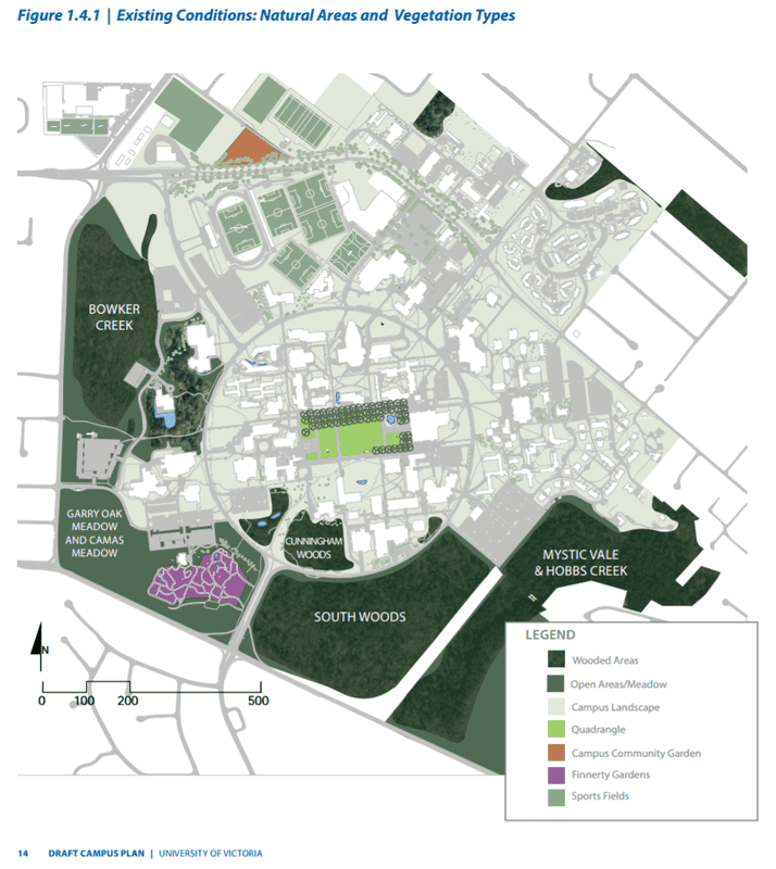
Figure 5: Representation from the Campus Plan (2015) of natural spaces and the types of vegetation on UVic property; this helps to express the highly developed and novel ecology of the area within Ring Rd and its embeddedness within surrounding hybrid ecosystems.
|
also be considered a hybrid system. While the hydrology of the small site is relatively functional, there are many other influences- such as deer browsing and management practices, that have caused many plant species to die (Kathrens & Jennings, 2016). While the university campus can be considered a novel ecosystem there are many functional hybrid systems within the landscape that have the potential to be seriously revitalized through connectivity and other restoration practices.
The largest natural areas left within the ring road are Cunningham Woods and the Vancouver Island Public Interest Group native plant garden located in the south west corner of the ring road. The native plant garden has been subject to landscape design and has been heavily modified and landscaped to represent native vegetation. Cunningham Woods is also a great source of biodiversity within the ring road. It was originally connected to the South woods section of the campus before development fractured it. Cunningham Woods is a mostly flat coniferous woodland with a wet depression area that will become inundated with water during winter months from storm water surges (Harrop-Archibald, H. 2007). The coniferous woodland is dominated by grand fir (Abies grandis) and Douglas fir in the top story with ocean spray (Holodiscus discolor), snowberry (Symphoricarpos), English ivy (Hedera helix), and trailing blackberry (Rubus ursinus) in the shrub layer (Harrop-Archibald, H. 2007). Species that are also found within this area include red-osier dogwood (Cornus sericea), Indian plum (Oemleria cerasiformis), English hawthorn (Crataegus laevigata), Himalayan blackberry (Rubus armeniacus), dull Oregon grape (Mahonia nervosa), bald-hip rose (Rosa gymnocarpa), sword fern (Polystichum munitum), and bracken fern (Pteridium). In the center of the woodland area there are several dead and dying trees possibly due to the increased water table (Harrop-Archibald, H. 2007). The wet depression area also contains several different trees including red-osier dogwood, willow, red alder (Alnus rubra), and aspen (Populus). Overall, Cunningham Woods has trees roughly 75 to 100 years old based on stand age and tree diameter data (Harrop-Archibald, H. 20072). The course woody debris found on the ecosystem floor is lower than comparable healthy ecosystems and this can be attributed to historical firewood collection, logging and land clearing (Harrop-Archibald, H. 2007). It should also be noted that while this area has been subject to restoration activities, the native vegetation still competes heavily with English ivy, English holly, and Himalayan blackberry. While other areas on campus are perpetually protected, Cunningham Woods is not (University of Victoria, 2015); consequently, there still exists the potential to develop one of the few hybrid ecosystems within Ring Road that haven’t crossed the restoration threshold. This poses a broader point that ecosystems inside the ring have crossed the threshold as a result of political uncertainty, and until more natural sites are protected from the threat of development they will suffer from a lack of resources allocated towards effective restoration.
The political conditions on the UVic campus are nested in two major decision making bodies: the Board of Governors and the Senate. The Board of Governors responsibilities include the administration, management, and control of the property and handling of the revenue and business affairs of the university, whereas the Senate is in charge of academic governance (University of Victoria, 1996). Land use decisions typically require consultation with the Senate, and relate to maintaining, constructing, and making “rules respecting the management, government, and control of the real property” on campus (University of Victoria, 1996; part 6, sec. 27); the Senate is also consulted on decisions “around conservation of heritage, buildings, structures, or landscapes of the university (University of Victoria, 1996; part 7, sec. 35).
The municipal jurisdictions of this land, divided between Oak Bay (about 40%) and Saanich (about 60%), creating a myriad of complications considering “each municipality has its own set of bylaws and regulations that apply to land use planning and development approvals” (University of Victoria, 2016; p.1). In particular, the zoning bylaws (Oak Bay: no. 3531; Saanich: no. 8200) establish various regulations around development and land-use that UVic governance incorporates in their planning procedures and submits to those municipal councils for approval (University of Victoria, 2016). UVic is also bound to the regulations delineated in the Sustainable Action Plan, developed in 2008 to employ a “triple bottom line” approach in guiding effective practices around 8 inter-related topics: energy and climate; transportation; purchasing; governance; decision-making and sustainability resources; buildings and renovations; grounds, food, and urban agriculture; water management; and waste management (Groves, 2009). This comprehensive report serves as a significant step forward into the sustainable future of social ecologies on campus, and was fostered in the 14-month collaborative consultation with students, faculty, and local communities that explored campus initiatives and best practices among other institutions (Groves, 2009; Cole & Wright, 2003). As a result, one can see that within a university environment, the capacity to involve communities, students, and faculty in relevant decisions around sustainability and land use is integral to creating meaningful change and disseminating valuable information around socio-ecological balance within Ring road.
Future trajectory
Previous sections have shown that the historical ecology within the University of Victoria campus grounds consisted of traditionally managed coastal Douglas Fir (Pseudotsuga menziesii) and Garry Oak (Quercus garryana) ecosystems; since then, European colonization and subsequent urban development have significantly altered the social and environmental dynamics within these rich ecosystems. We believe that future environmentally beneficial trajectories on UVic campus are dependent on the degree of socio-ecological connectivity established by the spaces, activities, and messages portrayed in UVic’s natural spaces. Essentially, the intention is to inspire dissemination of local ecological knowledge through exposure to green spaces so that communities are more invested in the both the process and product of the project.
One potential trajectory the University of Victoria continues on with ‘business-as-usual’ conditions in regards to campus policies, planning and projects. This would occur through results-based environmental values persisting in the form of new buildings being built under different quality control measures such as LEED Green Building standards, while incorporating green spaces for water infiltration. A business-as-usual approach would continue to provide inadequate support to different ecological or social restoration groups working to improve the campus green spaces, while encroaching on spaces that lack adequate protection, such as Cunningham Woods. Although UVic is ranked quite highly in university sustainability standards, we believe there are a few shortcomings if the university was to take a status quo approach to future development. Primarily, there is a disconnect between sustainable campus initiatives and promoting a holistic model of resilience, diversity, and connectivity in social ecologies on university grounds. The healthy ecology of many natural pockets on campus are significantly fragmented, but if the University upholds its commitments to incorporate sustainable practices, the ecological design of various edible gardens has the potential to “[create] positive relationships to the open spaces surrounding them” (UVic3, 2016). However, without seeing more appropriate resources, time and personnel allocated, balancing campus ecology will continue to be an uphill battle.
Thanks to incentives from the Campus Sustainability Fund, the Restoration of Natural Systems program- in conjunction with the Ecological Restoration Volunteer Network (ERVN), contribute significantly to the rejuvenation of natural spaces on campus (Marck, 2016). Val Schaefer, when speaking of restoration in Cunningham Woods, believes that the funding has allowed “the project to be more strategic and effective with inclusive student participation and educational outreach” (Marck, 2016; para.8). Therefore there is a lot of potential to see a future trajectory of intensified efforts and increased support from the University of Victoria Board of Governors (University of Victoria, 2016). The University Senate also poses an important role of validating the potential curricular benefits that accumulate from a network of applied education sites; as an tremendously complex field, ecological restoration requires multi-dimensional knowledge systems that classroom settings simply cannot provide (University of Victoria, 2016; Turner, 2014; Marck, 2016). By allocating more resources and support to these areas, students and faculty can mobilize to eradicate invasive species, while implementing effective strategies to mitigate ecological and hydrological concerns associated with fragmentation and development. A variety of natural spaces on campus can serve as experimental plots to provide practical knowledge on the intricacies of local restoration frameworks and ecology on campus.
This trajectory also builds resilience in natural spaces with the consistent allocation of research and restoration efforts, in addition to creating a vector for students and volunteers to mobilize around a common resource. This model resembles the intermediate effort allocated to sustainability, but “success or failure usually rests on the extent to which communities and stakeholders are actively engaged” (Keenleyside et. al, 2015; p.14); as a result, the university’s support in mobilizing co-management within students, stakeholders, and faculty is pivotal for sustained growth in this trajectory. The continuation of these trends- with potential to expand in further recognition of the embedded ecological, educational, and aesthetic values of UVic natural spaces, is expected to catalyze the emergence of sustainable agro-forestry spaces, native pollinator gardens, and edible landscapes with interactive art/education features.
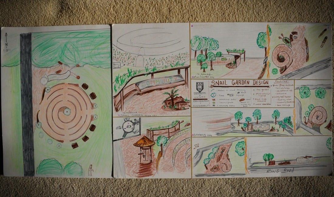
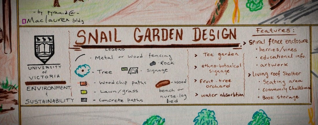
An ideal approach to promoting socio-ecological connectivity on the UVic campus involves introducing features that enable the university populus to interact, learn, and refuel through sustainable agro-ecosystems. We believe this to be ideal because it strives to combine permaculture design practices within ecological restoration objectives, and shifts focus towards social interactions and ethnobotanical connectivity as a vector for increased resilience. Using the example of a proposal by Matt Kemp- submitted in the UVic edible landscape design contest, the goal was to establish a garden that housed edible plants and an interactive art feature which inherently has the capacity to engage people on campus (Kemp, 2016). In addition, the UVic Campus Plan mentions plans to develop more weather protection infrastructure around “building entrances to correspond with a connected network of pathways” whilst providing other features to shelter commuters from rain (UVic3, 2016; p.65), which could certainly complement this edible garden network. He then expanded the idea to foster socio-ecological connectivity by installing a dozen of these spaces- ranging in size, interaction, and ecology, in areas currently filled with open grass or impermeable surfaces.
The Society of Ecological Restoration strives to re-establish an ecologically healthy relationship between nature and culture in order to ensure resilience and sustainability through interdependence, which serves as one of the pillars of this trajectory (Keenleyside et. al, 2015; Yu et. al, 2012). With further recognition and integration of TEK systems, the university would explore avenues for co-management with First Nations groups both on and off campus. These practices will take “account of cultural diversity and long-standing approaches to sustainable human participation in ecosystems” in addressing ethnobotanical research and application with the highest regard (Uprety et. al, 2012; p.228; Yu et. al, 2012). The hope in creating these spaces is that people are inspired to take a moment on their commute to stop, disconnect from the busy-ness, and calm oneself. Developing a network of these spaces is particularly relevant on a university campus considering its capacity to “facilitate healthy mentalities within students by offering a place to slow down, relax, reflect, refuel, and reconnect” (Kemp, 2016). In addition, they can be integrated seamlessly with educational signage for plants, ethnoecology, sustainable technologies, and maybe even local artists. Lastly, it serves as a platform for conversation, with the potential to catalyze interactions between students, staff, and faculty passing through for the same reasons, and enjoying some hand-picked tea.
Conclusion
This project analyzes the modern and historical pressures that have shaped the University of Victoria campus, and in establishing the parameters of ecological integrity within select hybrid and novel ecosystems on campus, we can begin to build a solution that combines social connectivity with ecological restoration. Reflecting on a rich history of ethnobotanical, agricultural, military, and educational uses, this property has been highly altered and pressured towards novel regimes, yet many sections of campus are still considered hybrid. Shaped by social and political regimes, such motives have produced an impressive university, but facilitating a holistically functioning property involves the integration of social and ecological components to compliment the natural areas throughout campus. Our proposed trajectory seeks to promote social-ecological connectivity by creating meaningful spaces that facilitate engagement on campus with creative agro-ecology. By creating 3 trajectories, we presented a spectrum of conscious efforts by decision makers to promote engagement amongst any visitors on campus, while enhancing green-spaces within a diverse web of connective habitat. The result is a marvel of ecological design that buzzes with life and interaction as permaculture, restoration, and eco-architecture combine to enhance socio-ecological resilience within UVic’s natural spaces.
One potential trajectory the University of Victoria continues on with ‘business-as-usual’ conditions in regards to campus policies, planning and projects. This would occur through results-based environmental values persisting in the form of new buildings being built under different quality control measures such as LEED Green Building standards, while incorporating green spaces for water infiltration. A business-as-usual approach would continue to provide inadequate support to different ecological or social restoration groups working to improve the campus green spaces, while encroaching on spaces that lack adequate protection, such as Cunningham Woods. Although UVic is ranked quite highly in university sustainability standards, we believe there are a few shortcomings if the university was to take a status quo approach to future development. Primarily, there is a disconnect between sustainable campus initiatives and promoting a holistic model of resilience, diversity, and connectivity in social ecologies on university grounds. The healthy ecology of many natural pockets on campus are significantly fragmented, but if the University upholds its commitments to incorporate sustainable practices, the ecological design of various edible gardens has the potential to “[create] positive relationships to the open spaces surrounding them” (UVic3, 2016). However, without seeing more appropriate resources, time and personnel allocated, balancing campus ecology will continue to be an uphill battle.
Thanks to incentives from the Campus Sustainability Fund, the Restoration of Natural Systems program- in conjunction with the Ecological Restoration Volunteer Network (ERVN), contribute significantly to the rejuvenation of natural spaces on campus (Marck, 2016). Val Schaefer, when speaking of restoration in Cunningham Woods, believes that the funding has allowed “the project to be more strategic and effective with inclusive student participation and educational outreach” (Marck, 2016; para.8). Therefore there is a lot of potential to see a future trajectory of intensified efforts and increased support from the University of Victoria Board of Governors (University of Victoria, 2016). The University Senate also poses an important role of validating the potential curricular benefits that accumulate from a network of applied education sites; as an tremendously complex field, ecological restoration requires multi-dimensional knowledge systems that classroom settings simply cannot provide (University of Victoria, 2016; Turner, 2014; Marck, 2016). By allocating more resources and support to these areas, students and faculty can mobilize to eradicate invasive species, while implementing effective strategies to mitigate ecological and hydrological concerns associated with fragmentation and development. A variety of natural spaces on campus can serve as experimental plots to provide practical knowledge on the intricacies of local restoration frameworks and ecology on campus.
This trajectory also builds resilience in natural spaces with the consistent allocation of research and restoration efforts, in addition to creating a vector for students and volunteers to mobilize around a common resource. This model resembles the intermediate effort allocated to sustainability, but “success or failure usually rests on the extent to which communities and stakeholders are actively engaged” (Keenleyside et. al, 2015; p.14); as a result, the university’s support in mobilizing co-management within students, stakeholders, and faculty is pivotal for sustained growth in this trajectory. The continuation of these trends- with potential to expand in further recognition of the embedded ecological, educational, and aesthetic values of UVic natural spaces, is expected to catalyze the emergence of sustainable agro-forestry spaces, native pollinator gardens, and edible landscapes with interactive art/education features.
An ideal approach to promoting socio-ecological connectivity on the UVic campus involves introducing features that enable the university populus to interact, learn, and refuel through sustainable agro-ecosystems. We believe this to be ideal because it strives to combine permaculture design practices within ecological restoration objectives, and shifts focus towards social interactions and ethnobotanical connectivity as a vector for increased resilience. Using the example of a proposal by Matt Kemp- submitted in the UVic edible landscape design contest, the goal was to establish a garden that housed edible plants and an interactive art feature which inherently has the capacity to engage people on campus (Kemp, 2016). In addition, the UVic Campus Plan mentions plans to develop more weather protection infrastructure around “building entrances to correspond with a connected network of pathways” whilst providing other features to shelter commuters from rain (UVic3, 2016; p.65), which could certainly complement this edible garden network. He then expanded the idea to foster socio-ecological connectivity by installing a dozen of these spaces- ranging in size, interaction, and ecology, in areas currently filled with open grass or impermeable surfaces.
The Society of Ecological Restoration strives to re-establish an ecologically healthy relationship between nature and culture in order to ensure resilience and sustainability through interdependence, which serves as one of the pillars of this trajectory (Keenleyside et. al, 2015; Yu et. al, 2012). With further recognition and integration of TEK systems, the university would explore avenues for co-management with First Nations groups both on and off campus. These practices will take “account of cultural diversity and long-standing approaches to sustainable human participation in ecosystems” in addressing ethnobotanical research and application with the highest regard (Uprety et. al, 2012; p.228; Yu et. al, 2012). The hope in creating these spaces is that people are inspired to take a moment on their commute to stop, disconnect from the busy-ness, and calm oneself. Developing a network of these spaces is particularly relevant on a university campus considering its capacity to “facilitate healthy mentalities within students by offering a place to slow down, relax, reflect, refuel, and reconnect” (Kemp, 2016). In addition, they can be integrated seamlessly with educational signage for plants, ethnoecology, sustainable technologies, and maybe even local artists. Lastly, it serves as a platform for conversation, with the potential to catalyze interactions between students, staff, and faculty passing through for the same reasons, and enjoying some hand-picked tea.
Conclusion
This project analyzes the modern and historical pressures that have shaped the University of Victoria campus, and in establishing the parameters of ecological integrity within select hybrid and novel ecosystems on campus, we can begin to build a solution that combines social connectivity with ecological restoration. Reflecting on a rich history of ethnobotanical, agricultural, military, and educational uses, this property has been highly altered and pressured towards novel regimes, yet many sections of campus are still considered hybrid. Shaped by social and political regimes, such motives have produced an impressive university, but facilitating a holistically functioning property involves the integration of social and ecological components to compliment the natural areas throughout campus. Our proposed trajectory seeks to promote social-ecological connectivity by creating meaningful spaces that facilitate engagement on campus with creative agro-ecology. By creating 3 trajectories, we presented a spectrum of conscious efforts by decision makers to promote engagement amongst any visitors on campus, while enhancing green-spaces within a diverse web of connective habitat. The result is a marvel of ecological design that buzzes with life and interaction as permaculture, restoration, and eco-architecture combine to enhance socio-ecological resilience within UVic’s natural spaces.
References
Cole, L. and Wright, T., 2003. Assessing sustainability on Canadian University campuses: development of a campus sustainability assessment framework. Unpublished master’s thesis, Royal Roads University, Victoria, BC.
Groves, M. 2009. Sustainability at UVic; Making policy, taking action [webpage]. Campus Planning and Sustainability, April 1, 2009. Accessed from: http://ring.uvic.ca/news/sustainability-uvic-making-policy-taking-action
Harrop-Archibald, H. 2007. University of Victoria Natural Features Study Phase One. Bowker Creek, Cunningham Woods, Upper Hobbs Creek/ Mystic Vale. University of Victoria Facilities Management. Unpublished Document. Victoria, British Columbia.
Harrop-Archibald, H. 20072. University of Victoria Campus Tree Inventory (Phase I) within Ring Road. University of Victoria Facilities Management. Unpublished Document. Victoria, British Columbia.
Harrop-Archibald, H. 2008. University of Victoria Campus Tree Inventory (Phase 2) outside of Ring Road. University of Victoria Facilities Management. Unpublished Document. Victoria, British Columbia.
Harrop-Archibald, H. 20082. University of Victoria Natural Features Study Phase Two. CJVI Property, Garry Oak Meadow and Camus Meadow Area, Finnerty Ravine, Haro Woods, South Woods, Lower Hobbs Creek/Mystic Vale. University of Victoria Campus Planning. Unpublished Document. Victoria, British Columbia.
Hobbs, R. J., Higgs, E., & Hall, C. M. (2013). Novel ecosystems: Intervening in the new ecological world order. Chichester, West Sussex: Wiley-Blackwell.
Jupp, U. (1975). From Cordwood to Campus in Gordon Head: 1852-1959. Estate of Ursula Jupp, Victoria, B.C.
Kathrens, L & Jennings, J. 2016. University of Victoria Invasive species Management Strategy. Unpublished document. Victoria, British Columbia.
Keenleyside K., Dudley N., Cairns S., Hall C., & Stolton S. (2015) Ecological Restoration for Protected Areas: principles, guidelines, and best practices. IUCN WCPA Ecological Restoration Taskforce. Society for Ecological Restoration, 2015. Accessed from: http://www.ser.org/page/SERDocuments
Kemp, M. (2016). Snail Garden: art/engagement proposal for UVic edible landscape design contest. Unpublised submission, October 19, 2016.
Lloyd, R.H. 2004. Integrated Storm Water Management Plan. University of Victoria Project No. 02-4367. Unpublished Document. Victoria, British Columbia.
Lovell D. & Turner J. (1999). The Changing Face of University of Victoria Campus Lands [webpage]. University of Victoria Archives, 1999; ISBN 1-55058-204-6. Accessed from: http://archives.library.uvic.ca/featured_collections/changing_face_uvic_campus/acknowledgements.html
Marck, P. (2016). Controlling Invasive Species on Campus. University of Victoria - News. October 5, 2016. Accessed from: http://www.uvic.ca/home/about/campus-news/2016+controlling-invasive-species+ring
McArthur, L. (2013). Donation to UVic from mining behemoth attracts criticism. The Martlet. Retrieved from http://www.martlet.ca/donation-to-uvic-from-mining-behemoth-attracts-criticism/
Polanyi, K. (2001). The great transformation: The political and economic origins of our time. Boston, MA: Beacon Press.
Service, C. N., Nelson, T. A., Paquet, P. C., Mclnnes, W. S. S., & Darimont, C. T. (2012). Pipelines and parks: Evaluating external risks to protected areas from the proposed northern gateway oil transport project. Natural Areas Journal, 32(4), 367-376. doi:10.3375/043.032.0404
Shugar, D. H., Walker, I. J., Lian, O. B., Eamer, J. B., Neudorf, C., Mclaren, D., & Fedje, D. (2014). Post-glacial sea-level change along the Pacific coast of North America. Quaternary Science Reviews, 97, 170-192. doi:10.1016/j.quascirev.2014.05.022
Thurber Engineering Ltd. (2003). UVic Storm Water Disposal Study Geotechnical/ Geological Conditions. Unpublished Document. Victoria, British Columbia.
Turner, N. J. (2014). Ancient pathways, ancestral knowledge: Ethnobotany and ecological wisdom of Indigenous peoples of northwestern North America. Montreal: McGill-Queen's University Press.
University of Victoria (1996). University Act [pdf]. RSBC 1996 ch.468, Victoria, BC; last modified October 12, 2016. Accessed from: http://www.bclaws.ca/EPLibraries/bclaws_new/document/ID/freeside/00_96468_01#section39
University of Victoria (2015). University of Victoria Campus Plan. Commissioned by the University of Victoria Campus Planning and Sustainability and prepared by DIALOG.
University of Victoria (2016). The Edge of Achievement: 2016 Annual Review [pdf]. University of Victoria, March 2016. Accessed from: http://www.uvic.ca/annualreview/
University of Victoria2 (2016). Green Buildings [webpage]. Campus planning and sustainability, 2016. Accessed from: https://www.uvic.ca/campusplanning/about/green-buildings/index.p
University of Victoria3 (2016). University of Victoria Campus Plan. Campus Planning and Sustainability, with help from DIALOG, Hapa Collaborative, Bunt & associates, Kerr Wood Leidel, & FVB energy. January 26, 2016.
Uprety, Y., Asselin, H., Bergeron, Y., Doyon, F., & Boucher, J. (2012). Contribution of traditional knowledge to ecological restoration: Practices and applications. Ecoscience, 19(3), 225-237. doi:10.2980/19-3-3530
University of Victoria4 (2016). Planning and Development Regulations: Saanich and Oak Bay [webpage]. Campus planning and sustainability, 2016. Accessed from: https://www.uvic.ca/campusplanning/about/regulations/index.php
Yu, D., Xun, B., Shi, P., Shao, H., & Liu, Y. (2012). Ecological restoration planning based on connectivity in an urban area. Ecological Engineering, 46, 24-33. doi:10.1016/j.ecoleng.2012.04.033
Figures:
Title page figure: Kemp, Matt (2016). Snail Garden Design [hand rendering]. Submitted for the University of Victoria Edible Landscape Design contest, November 24, 2016.
1. University of Victoria. University Map Collection. Map of Victoria and part of Esquimalt Districts, 1861. 1:15; 4 inch:1 mile. London: Day & Son lithographers; 1861. Accessed from: http://contentdm.library.uvic.ca/cdm/singleitem/collection/collection5/id/137/rec/4
2. University of Victoria. University Map Collection. (BA 227-68). Victoria: 1928. Other information unavailable
3. University of Victoria. University Map Collection. B.C. Government Air Photograph (BC 5091-257). Victoria: Department of Lands, Forests, & Water Resources: May 15, 1964.
4. University of Victoria. University Map Collection. (BC 5671-127). Victoria: 1977. Other information unavailable
5. University of Victoria (2015). University of Victoria Campus Plan. Commissioned by the University of Victoria Campus Planning and Sustainability and prepared by DIALOG.
