Geographical and ecological settingThe south-facing hillside known by the Lekwungen as Meegan looks out from Victoria BC to the mountains of the Olympic Peninsula that lie across the straight of Juan de Fuca. The site is one of the last remnants of the Garry oak (Quercus garryana) meadows and the accompanying Kwetlal (camas) food system that were created and maintained by the Lekwungen ancestors. This food system ecology has been managed for thousands of years using complex systems of land management and social organization. The Kwetlal food system was once so abundant in this region that the camas harvest made a major contribution to the sustenance of Lekwungen families, and also provided an important item of trade with other indigenous nations. This endangered ecosystem is of major importance to Lekwungen people not just ecologically, but culturally and economically.
Shortly after the arrival of British settlers in the mid-1840s, the Lekwungen were dispossessed of their lands and prohibited from conducting practices such as controlled burning that had long been used to maintain the Kwetlal food system (Snelgrove, 2014). The Garry oak meadows were rapidly degraded and destroyed by settler practices such as agricultural and urbanization (Beckwith 2004; MacDougal et al 2004; Turner 1999). Today, only 5% of the Garry oak ecosystem that existed prior to colonization remains – 1,200 acres of what once covered nearly 26,000 acres in Greater Victoria (Lea, 2006). Much of what is left is patchy and located on rocky hill tops with shallow soils (Lea, 2006). Other patches remain threatened by continued urban development. In addition to this drastic decline in the distribution of Victoria’s Garry oak ecosystem, the biodiversity and ecological integrity of remaining patches have been severely compromised. As MacDougall et al. (2004) have observed, “Remnant areas no longer contain the structural diversity that was described formerly and are dominated by exotic flora that appear to be competitively superior to other species in these undisturbed settings” (p .462). The Garry Oak Ecosystem Recovery Team has reported that over 100 species native to the Garry oak ecosystem are currently reported to be at risk. Further, nearly one-third of the species that are currently found in Vancouver Island’s Garry oak meadows are not historically native species (GOERT). Many of these species were introduced by European settlers for either agricultural or ornamental purposes, while others species were introduced unintentionally. The health and integrity of the Kwetlal food system has been compromised as a consequence of these compounding processes of dispossession and urbanization, as well as the introduction of non-native species and the prohibition of traditional land management practices. To the extent that the City of Victoria manages the remaining patches of Garry oak meadows in the parks system, they are typically treated as greenspaces to be preserved rather than being managed as a food system. These non-traditional management practices result in a reduction of the size and quantity of camas bulbs (Beckwith, 2004). Despite these many challenges, the Lekwungen and their allies continue to manage the Kwetlal fields as a practice of cultural resurgence, decolonization, and reinstatement of the Lekwungen food system. |
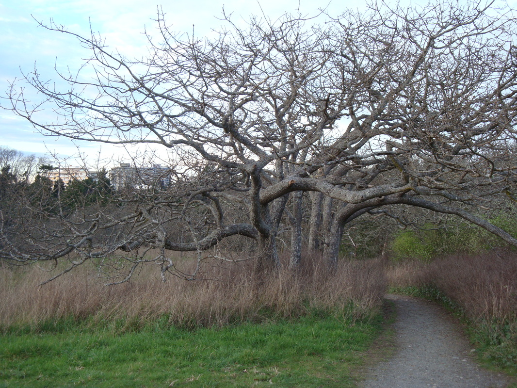
Garry Oak Meadow in Beacon Hill Park (Meegan), Victoria BC 2015
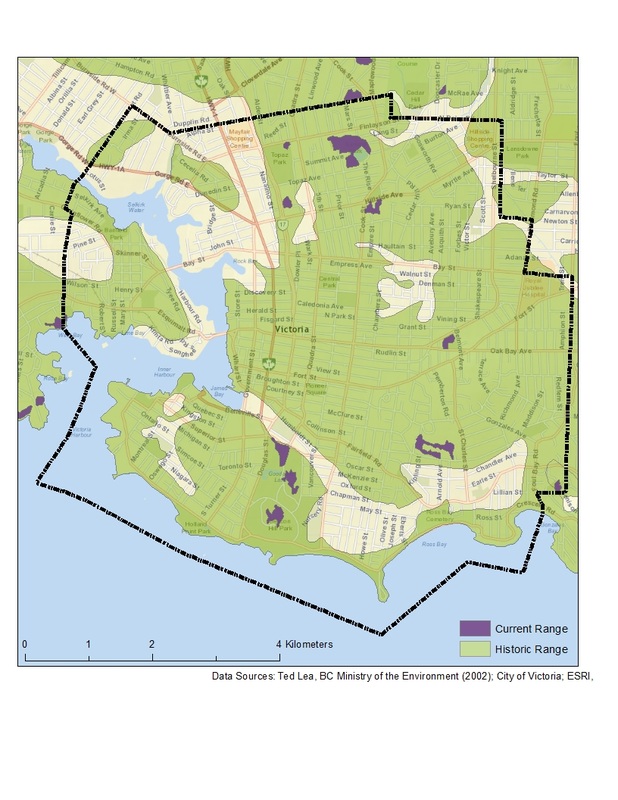
Historic and Current Range of Garry Oak Meadows in Victoria, BC
|
- Home
-
Case studies
-
2024
>
- Making Friends with Water
- Managing the Lionfish Crisis in the Caribbean
- Avian Havens in the Concrete Jungle
- Ealgrass Meadows in Clayoquot Sound
- Post-Pasture Regeneration in Northern Australia
- Seal River Estuary
- Cheonggyecheon Restoration Project
- Synthetic Coral Reefs
- Killer Algae
- Naa'Waya'Sum Gardens
- Boundary Bay Salt Marshes
- Rewilding and Recolonizing Singapore
- Dam Removal at Jordan River
- Dam Removal in the Elwha River
- Gut Bacteria Manipulation in Invasive Mosquitoes
- Mangrove Forests Aquaculture
- The Pacific Oyster
- Prairie Wetland Restoration
- Blight-Resistant American Chestnut Tree
- Invasives Restoring Butterflies
- Garry Oak Ecosystems
-
2019
>
- Aral Sea
- Assisted Migration Adaptation Trial
- Beacon Hill Park
- Cape Town Water Crisis
- Carpathian Rewilding
- Cutthroat Conundrum
- Eelgrass Wasting Disease
- European Wolf Rewilding
- Gorongosa National Park
- Great Lakes Invasion
- Mountain Goat Removal
- Native to Invasive
- Plains Bison Reintroduction
- Rewilding the Danube Delta
- Rewilding Victoria
- South Purcells Caribou
- 2016 >
-
2015
>
-
2024
>
- Contact
